
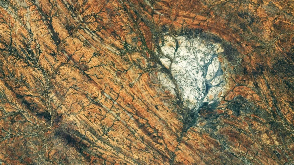
In the arid, sun-drenched landscape of southern Madagascar, a striking geological anomaly disrupts the dusty, reddish terrain. From the vantage point of the International Space Station (ISS), this formation appears as a luminous, roughly circular scar of bright white—a stark departure from the heavily deformed, darkened rocks that define the region. This is the Saririaky anorthosite massif, a 100-square-kilometer exposure of igneous rock that serves as a terrestrial twin to the bright, reflective highlands that dominate the surface of our Moon.
While anorthosite is a rarity on the surface of Earth today, it is a primary constituent of the lunar crust. The discovery and subsequent high-resolution photography of the Saririaky massif offer geologists a unique laboratory to study the mechanisms of crustal formation, providing a bridge between the tectonic evolution of our own planet and the ancient, frozen history of the Moon.
The Lunar Connection: Anorthosite and the Magma Ocean
To understand the significance of the Saririaky formation, one must first look toward the heavens. The Moon’s bright, light-colored highlands—the regions visible to the naked eye as the pale expanses of the lunar face—are composed largely of anorthosite. This rock type is a specialized form of igneous material, rich in plagioclase feldspar, which gives it a high albedo, or reflectivity.
Lunar scientists believe these highland anorthosites are among the oldest materials in the solar system, dating back more than 4 billion years. According to the leading hypothesis, the young Moon was essentially a molten sphere—a global magma ocean. As this ocean cooled, lighter minerals like plagioclase crystallized and floated to the surface, forming a buoyant "crust" of anorthosite. This primordial crust eventually solidified, creating the foundations of the lunar landscape we observe today.
Because lunar samples are finite and difficult to obtain, Earth’s own anorthosite deposits—found in scattered locations such as Montana’s Beartooth Mountains, Scandinavia, eastern Canada, and now prominently featured in southern Madagascar—serve as vital proxies. By studying the cooling rates and chemical signatures of terrestrial anorthosite, geologists can refine their models of how the Moon’s early crust differentiated and evolved.
Chronology: A 600-Million-Year Journey
The history of the Saririaky massif is a deep-time epic, tracing back to the late Precambrian, at least 600 million years ago. Its existence is not merely a testament to the cooling of ancient magma, but to the violent restructuring of the Earth’s crust.
The Igneous Birth
Deep beneath the ancient surface, magma cooled slowly, allowing for the growth of the large, distinct crystals that characterize intrusive igneous rock. This process took place far from the light of day, hidden within the Earth’s mantle or deep crust. It was only through hundreds of millions of years of tectonic uplift and subsequent erosion that this "Moon-rock" was finally exposed to the surface of Madagascar.
The Collision of Continents
The formation of the massif occurred against the backdrop of the assembly of Gondwana. This massive supercontinent, which eventually unified much of the landmasses of the Southern Hemisphere, was the result of the collision of various continental fragments. As these blocks smashed together, the Saririaky massif was thrust into what geologists identify as a "ductile shear zone."
Deformation and Tectonic Stretching
The surrounding landscape of Saririaky bears the scars of these immense forces. The rock was subjected to extreme heat and pressure, causing it to undergo "metamorphism"—a process where solid rock behaves like thick putty, bending and stretching without fracturing. This period of intense deformation created long, parallel geological features that define the region today.
Supporting Data: The Anatomy of a Shear Zone
The geological architecture of southern Madagascar provides a roadmap of these ancient continental collisions. The Saririaky massif does not sit in isolation; it is part of a complex system of ductile shear zones.
Geological mapping has revealed that the rocks surrounding the massif have been subjected to significant "foliation," where minerals align in specific patterns due to directional stress. This orientation confirms that the region was subjected to massive horizontal forces as the fragments of Gondwana converged.
One of the most compelling pieces of evidence for these extreme tectonic forces is the theory of "boudinage." Researchers observing the region have noted a second anorthosite massif located approximately 60 kilometers to the north. Evidence suggests that these two bodies were once a single, continuous formation. As the Earth’s crust pulled and stretched during the formation of the supercontinent, the original rock body was fractured and separated, much like a piece of taffy being pulled apart. This "boudinage" effect serves as a natural record of the literal stretching of the crust, providing scientists with quantifiable data on the magnitude of the tectonic forces involved in supercontinent assembly.
Official Documentation: NASA’s Orbital Perspective
The significance of the Saririaky formation was highlighted once again on August 28, 2026, when an astronaut aboard the International Space Station captured a high-resolution photograph of the massif (ISS075-E-85249). Utilizing a Nikon Z9 digital camera paired with a 400-millimeter focal-length lens, the crew member was able to document the site with unprecedented clarity from an altitude of roughly 400 kilometers.
According to NASA’s Earth Science and Remote Sensing Unit at the Johnson Space Center, the image underwent minor processing to improve contrast and remove lens artifacts, ensuring that the geological structures were clearly visible for academic review. This photograph is not merely a scenic souvenir; it is a vital tool for planetary geologists who use such imagery to correlate surface patterns with established geological surveys. The visibility of the massif from orbit underscores its distinct composition, as the light-colored rock reflects significantly more light than the surrounding, darker, iron-rich metamorphic rocks of the region.
Implications for Planetary Science
The study of the Saririaky massif holds implications that extend well beyond the borders of Madagascar. As human interest in lunar exploration intensifies, the ability to interpret the history of the Moon through the lens of terrestrial geology becomes paramount.
Refining Lunar Models
By identifying the specific geochemical markers in the Saririaky anorthosite, scientists can better compare these samples to those brought back by the Apollo missions. If terrestrial anorthosites match the lunar samples in mineralogical composition and crystal structure, they provide a reliable baseline for testing theories about the "magma ocean" hypothesis.
A History of Earth’s Crust
Furthermore, the Saririaky formation is a crucial witness to the evolution of Earth’s own crust. The process of boudinage and the identification of ductile shear zones help researchers map the hidden suture lines where ancient continents were joined. This allows geologists to reconstruct the history of Gondwana with higher precision, turning the barren plains of Madagascar into a high-stakes classroom for Earth’s pre-human history.
Future Research
The geological research conducted on the Saririaky massif, as evidenced by scholarly investigations into its formation (such as studies published in the Journal of Petrology), continues to emphasize the utility of remote sensing. As more satellite and orbital data become available, researchers expect to uncover even more of these "lunar" anomalies hidden within the Earth’s complex tectonic landscape.
In conclusion, the Saririaky anorthosite massif is more than just a geological curiosity. It is a bridge between worlds. By examining how Earth’s ancient, reflective crust was shaped by the titanic forces of supercontinent formation, we gain a clearer understanding of the primordial processes that birthed our Moon. Whether viewed from the ground as a strange, pale outcrop or from the vacuum of space as a beacon of light, the Saririaky massif stands as a permanent, silent reminder of the shared, violent, and magnificent history of the Earth-Moon system.