In early September 2026, the restless Anak Krakatau—the "Child of Krakatoa"—reminded the world of its volatile power. Situated in the Sunda Strait between the Indonesian islands of Java and Sumatra, the small but formidable volcano entered a prolonged, explosive phase that paralyzed air travel, degraded air quality for millions, and necessitated a massive humanitarian response. The event serves as a stark reminder of the geological instability that characterizes the Indonesian archipelago, a region perched precariously on the "Ring of Fire."
The Anatomy of an Eruption: Main Facts
The eruptive sequence, which reached its zenith on September 5, 2026, was not merely a localized geological event but a widespread atmospheric disruption. Unlike the subtle, periodic Strombolian activity that typically defines Anak Krakatau’s daily existence, this event involved a sustained, violent release of gas and pulverized rock that persisted for over 24 hours.
The sheer volume of material ejected was significant enough to penetrate the upper troposphere. By September 6, meteorological agencies confirmed that volcanic ash had reached altitudes of 6,000 meters (20,000 feet) to the east and a staggering 15,000 meters (50,000 feet) to the west. This vertical reach meant the ash plumes were caught in high-altitude wind currents, effectively distributing particulate matter across major population centers, including the sprawling capital of Jakarta.
The environmental impact was immediate. As the plume dispersed, it created a dual-threat scenario for residents: the inhalation of abrasive volcanic ash and the obscuring of the atmosphere, which plummeted visibility to dangerous levels for aviation.
Chronology of the Crisis
The escalation of activity did not occur without warning, yet the intensity of the early September event caught the region off guard.
- Early July 2026: Anak Krakatau is placed on the second-highest alert level by Indonesian authorities following signs of subsurface magma migration.
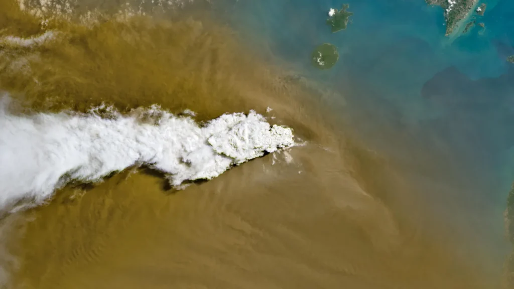
- September 5, 2026: The volcano enters a major explosive phase. Satellite sensors, including the OLI aboard Landsat 8 and the VIIRS on Suomi NPP, capture the eruption in real-time. A massive, bright white plume of gas rises alongside dark, dense ash clouds.
- September 6, 2026: The crisis reaches its peak. Eight major airports across Java and Sumatra are forced to close as ash density makes flight paths untenable. Humanitarian agencies, including the Indonesian Humanitarian Coordination Platform (IHCP), issue urgent health warnings.
- September 7, 2026: The sustained, high-energy eruption begins to subside, shifting back to smaller, intermittent bursts.
- September 8, 2026: Authorities give the green light for air traffic to resume, though the volcano remains under strict observation due to its ongoing high-alert status.
Satellite Eyes: Scientific Observations
The 2026 eruption provided volcanologists with an unprecedented dataset. Because of the sophisticated suite of satellite instrumentation currently orbiting the Earth, the event was documented from multiple spectral angles.
The Operational Land Imager (OLI) on the Landsat 8 satellite provided high-resolution visual confirmation of the eruption’s composition. Imagery showed a clear bifurcation in the plume: a bright white column of volcanic gas—primarily water vapor and sulfur dioxide—soaring above a darker, heavier base of ash. This distinction is crucial for researchers attempting to model the density and temperature of eruptive columns.
Furthermore, the Visible Infrared Imaging Radiometer Suite (VIIRS) aboard the Suomi NPP satellite provided a "macro" view of the event. By capturing wider swaths of the Sunda Strait, VIIRS enabled scientists to track the long-range dispersal of the ash cloud as it drifted over the Java Sea. This data was instrumental in helping aviation authorities draw flight path exclusion zones, preventing commercial jets from flying into the abrasive, engine-clogging cloud.
The Aviation Crisis: 3,000 Flights Grounded
The impact of volcanic ash on modern aviation cannot be overstated. Volcanic ash is not like typical smoke; it is essentially pulverized glass and rock. When ingested by jet engines, the high temperatures of the combustion chamber melt these particles, which then fuse to the turbine blades, leading to total engine failure.
The decision to close eight airports was a prophylactic measure that likely prevented a catastrophic accident. With nearly 3,000 flights disrupted, the economic and logistical fallout was immense. Stranded passengers, stalled supply chains, and the complex task of rescheduling thousands of flights created a secondary crisis in the region’s transport hubs. While the airports reopened on September 8, the incident sparked renewed debate regarding the necessity of better real-time ash-tracking technology at the runway level.
Humanitarian and Health Implications
The fall of ash onto densely populated areas of West Java, including Jakarta, forced health authorities to pivot quickly. The IHCP, in its flash update on September 6, highlighted a critical distinction: the hazard from Anak Krakatau was fundamentally different from the annual haze caused by peatland fires in Indonesia.
The Science of Ash vs. Smoke
While peatland smoke is organic and chemical in nature, volcanic ash is mineral-based. The IHCP emphasized that the sharp, jagged edges of volcanic particles make them particularly damaging to the respiratory tract and the delicate membranes of the eyes. Consequently, the standard advice for wildfire smoke—remaining indoors—was insufficient. Residents were advised to wear N95-rated respirators and protective eyewear, as volcanic dust can permeate standard fabric masks and cause severe irritation.
The psychological toll on the population was also significant. Living under the shadow of a volcano that has been on high alert since July fostered a sense of "alert fatigue," yet the intensity of this particular eruption forced a return to emergency protocols and a renewed focus on community preparedness.
Current Status and Looking Ahead
As of the latest reports, Anak Krakatau has returned to a state of "Strombolian" activity—a more rhythmic, less violent pattern of periodic bursts. While this is a relief for the millions living in its shadow, it does not mean the danger has passed. The volcano remains at the second-highest alert level, a designation that dictates strict exclusion zones around the crater and continuous monitoring by the Indonesian Center for Volcanology and Geological Hazard Mitigation.
The resilience shown by the Indonesian people during this period is a testament to their long history of coexisting with geological hazards. However, the 2026 event serves as a critical case study for international disaster management. As global air traffic increases and climate change alters regional wind patterns, the ability to predict, monitor, and respond to volcanic events will become increasingly vital.
For now, the smoke has cleared, the runways are buzzing once more, and the "Child of Krakatoa" remains quiet. But for the scientists monitoring the tremors beneath the Sunda Strait, the work continues. Each eruption provides a new layer of data, a new lesson in the earth’s temperament, and a reminder that when it comes to the world’s most active volcanoes, the only certainty is change.
Data Sources: NASA Earth Observatory, U.S. Geological Survey (USGS), NASA EOSDIS LANCE, and the Indonesian Meteorological, Climatological, and Geophysical Agency (BMKG).