Introduction: A Celestial Presence on Earth
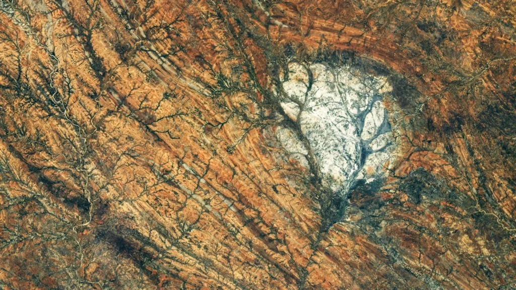
From the vantage point of the International Space Station (ISS), the Earth appears as a vibrant tapestry of blues, greens, and browns. Yet, occasionally, a feature emerges that seems entirely out of place—a stark, brilliant patch of white that feels more characteristic of the lunar surface than our own terrestrial home. On August 28, 2026, a member of the Expedition 75 crew aboard the ISS captured a striking photograph of the Saririaky anorthosite massif in southern Madagascar, a geological marvel that serves as a terrestrial echo of the Moon’s ancient highlands.
This formation, a sprawling body of bright, intrusive igneous rock, provides a rare, tangible link between the tectonic turmoil of Earth’s deep past and the primordial cooling of our closest celestial neighbor. By examining these rocks, geologists are not merely studying the history of Madagascar; they are uncovering a masterclass in planetary formation that spans from the supercontinents of Earth’s deep history to the magma oceans of the nascent Moon.
Main Facts: The Nature of Anorthosite
Anorthosite is not your average rock. Predominantly composed of plagioclase feldspar, it is an intrusive igneous rock that forms deep within the Earth’s crust. Its unique appearance—often a brilliant, light-reflecting white—is a direct result of its mineral composition.
Because anorthosite forms through the slow cooling of magma beneath the surface, the constituent minerals have the luxury of time to organize into large, well-defined crystals. On the Moon, these formations are the primary constituents of the lunar highlands, the bright, cratered regions that have captivated humanity for millennia. When early astronomers looked up and wondered why parts of the Moon were brighter than others, they were effectively observing the vast, ancient expanses of lunar anorthosite.
While the Moon possesses these formations in abundance, they are relatively rare on Earth. Significant terrestrial deposits are scattered across the globe, found in regions such as eastern Canada, Scandinavia, southern India, and the Saririaky region of Madagascar. The Saririaky formation is particularly notable for its roughly circular morphology, which stands in stark contrast to the heavily deformed, darker metamorphic rocks that surround it. Covering approximately 100 square kilometers, this massif acts as a geological beacon, signaling a history of extreme heat and pressure.
Chronology: A Journey Through Deep Time
To understand the Saririaky massif, one must look back to the late Precambrian, at least 600 million years ago. This was an era when the Earth’s surface looked vastly different, and the continents we recognize today were in the process of being forged through violent, transformative collisions.
The Assembly of Gondwana
The formation of the Saririaky massif coincides with the assembly of Gondwana, the colossal supercontinent that eventually united Africa, India, Madagascar, Australia, and Antarctica. During this period, the crust of the Earth was subjected to monumental tectonic forces. As these massive landmasses converged, the rocks trapped between them were squeezed, heated, and folded in a process geologists refer to as a "ductile shear zone."
In these high-pressure environments, solid rock behaves almost like plastic. Rather than shattering, the rock bends, stretches, and recrystallizes. This metamorphic process fundamentally altered the landscape of southern Madagascar, creating the long, north-to-south geological features that define the region today.
The Mystery of the Broken Massif
Current research suggests that the Saririaky massif was once part of a much larger, singular body of rock. Roughly 60 kilometers to the north, geologists have identified a second, similar anorthosite formation. The prevailing theory is that these two bodies were originally connected but were torn asunder by the intense tectonic forces of the Gondwana assembly.
This process, known as "boudinage," occurs when a hard, competent rock layer is encased in a softer, more ductile matrix. As the crust stretched, the harder anorthosite layer could not keep pace and was pulled into separate, isolated segments. If this interpretation holds, these two formations represent a preserved record of the immense tectonic energy involved in the creation of a supercontinent.
Supporting Data: Connecting Earth to the Moon
The scientific value of terrestrial anorthosite lies in its role as a proxy for lunar history. The lunar highlands are over 4 billion years old, representing some of the oldest crustal material in the solar system.
The Magma Ocean Hypothesis
Scientists believe that the young Moon was once covered by a global ocean of molten rock. As this magma ocean began to cool, lower-density minerals—specifically plagioclase feldspar—crystallized and floated to the surface, creating an insulating crust of anorthosite. This crust defines the lunar landscape we see today.
Because we have only a limited supply of actual lunar samples—brought back primarily by the Apollo missions—terrestrial analogs are critical. By studying the chemical composition and structural development of formations like the Saririaky massif or the Beartooth Mountains in Montana, researchers can refine their models of how the Moon cooled and solidified. These terrestrial sites allow scientists to observe how mineral chemistry changes under varying pressure-temperature conditions, providing a benchmark to test theories about the lunar interior.
Official Responses and Scientific Context
The photograph captured by the ISS crew on August 28, 2026, has been lauded by the geological community for its clarity and contextual value. The image, designated ISS075-E-85249, was acquired using a Nikon Z9 camera with a 400-millimeter lens, allowing for high-resolution analysis of the massif’s boundaries and the surrounding shear zone.
NASA’s Earth Science and Remote Sensing Unit has emphasized that such imagery is vital for modern geological mapping. "The ability to observe these formations from orbit allows us to see the ‘big picture’ of tectonic deformation that is often obscured when viewing the ground from a localized perspective," noted a representative from the Johnson Space Center. The data derived from these images helps geologists reconstruct the movement of crustal blocks during the Precambrian era, providing a clearer map of how Gondwana was stitched together.
Implications: The Future of Planetary Geology
The study of the Saririaky massif carries profound implications for the future of planetary science. As humanity prepares to return to the Moon through the Artemis program and other international initiatives, the need to understand lunar materials has never been greater.
A Laboratory for Global Tectonics
The Saririaky formation is more than just a beautiful geological oddity; it is a laboratory for studying the limits of continental deformation. The fact that this rock has remained identifiable despite 600 million years of erosion and tectonic shifting is a testament to its durability. Future studies of the massif will likely focus on the trace-element geochemistry of the rock to determine its precise crystallization age, which would provide a more accurate timeline for the tectonic events that shaped southern Madagascar.
Bridging the Gap
Furthermore, the research underscores the importance of comparative planetology. By treating the Earth as a planetary laboratory, we gain the necessary tools to interpret data from other worlds. Whether it is the lunar highlands or the icy crusts of moons orbiting gas giants, the fundamental physics of crystallization and deformation remain consistent.
The Saririaky massif reminds us that we do not need to leave the Earth to touch the cosmos. The same geological forces that built the Moon also built the foundations of our own continent. When we look at the bright, white expanse of the Saririaky massif from the safety of the ISS, we are looking at a mirror held up to our own origins.
As we continue to explore the solar system, these terrestrial sites will remain our most reliable guides, anchoring our understanding of the stars in the very bedrock of our home planet. The ancient, deformed rocks of Madagascar are not merely silent stones; they are the keepers of a story that links the formation of our planet to the silent, cratered face of the Moon, forever tying our terrestrial history to the broader evolution of the solar system.