SUDBURY, ON – Canuc Resources Corporation (TSX-V: CDA, OTCQB: CNUCF, WKN: A41V6H) has officially commenced an ambitious, high-resolution geophysical survey program across its 100% owned East Sudbury Project (ESP). This tactical initiative, currently being executed by the industry-leading Bell Geospace, marks a pivotal moment in the company’s efforts to modernize exploration within one of Canada’s most storied mining jurisdictions. By deploying cutting-edge Full Tensor Gradiometer (FTG), magnetic, and LiDAR technologies over a vast 200-square-kilometer land package, Canuc is shifting its gaze toward the untapped potential hidden deep beneath the surface of the Sudbury Basin’s periphery.
The Evolution of Exploration: Bridging History and Technology
The Sudbury region has long been defined by its rich geological history, with mining activity dating back to the early 20th century. However, despite decades of historical success—including over 45,000 meters of past drilling—exploration has largely remained confined to the shallow, near-surface environment.
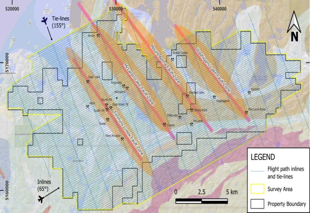
Canuc’s current campaign is designed to shatter these limitations. The survey program, which spans nearly 2,000 line-kilometers, represents one of the most comprehensive subsurface mapping projects in the area’s recent history. The objective is to transition from traditional, localized exploration to a regional, deep-crustal understanding of the ESP’s structural architecture.
Chronology of the Exploration Campaign
The current survey follows a strategic sequence of events aimed at de-risking the property and optimizing drill targets:
- July 2026: Canuc, in collaboration with OptiSeis Solutions Ltd. and Natural Resources Canada, successfully completed a high-resolution seismic program along the McLaren Lake Fault. This established the structural framework for the deeper, more complex surveys to follow.
- August 17, 2026: Bell Geospace officially mobilized its DC3 aircraft, initiating the airborne Full Tensor Gradiometer (FTG), magnetic, and LiDAR survey. This stage provides the high-resolution "eyes" necessary to visualize the internal density and magnetic contrasts of the earth’s crust.
- Late 2026 and Beyond: Upon completion of the survey, Canuc intends to synthesize the new geophysical data with historical regional geological datasets and the recent seismic results to feed into an AI-driven targeting model.
Technical Scope: The Power of FTG and LiDAR
The integration of three distinct geophysical tools provides a multi-layered view of the project’s geology.
Full Tensor Gradiometer (FTG)
FTG is the gold standard in gravity surveying. Unlike traditional gravimeters that measure a single vertical component of the earth’s gravitational field, the FTG measures the full gravity gradient tensor. This high-definition data allows geologists to map density contrasts at depth with exceptional precision, enabling the identification of large-scale geological structures and potential ore-bearing "plumbing" systems that remain invisible to surface prospecting.
Magnetic and LiDAR Surveys
While FTG maps density, the magnetic survey identifies susceptibility changes—critical for detecting iron-rich minerals often associated with Iron Oxide Copper Gold (IOCG) deposits. The LiDAR (Light Detection and Ranging) survey provides a hyper-accurate topographical map, stripping away vegetation to reveal subtle structural features and fault lineaments on the surface that might indicate mineralized trends.

By combining these data sets, Canuc is effectively creating a "3D CAT scan" of its 20,000-hectare land package. The primary focus is the McLaren Lake Fault and three newly identified sub-parallel fault structures, which are believed to be key conduits for hydrothermal fluids capable of depositing large-scale gold and copper mineralization.
Official Commentary: CEO Christopher Berlet on the "Deep-Look" Strategy
Christopher Berlet, CEO and Director of Canuc, emphasized the paradigm shift this program represents for the company.
"Despite a history of high-grade gold and copper mining dating back as far as 1904, and despite nearly 45,000 metres of historical drilling around old gold and copper mine workings, effectively no drilling or exploration has been undertaken beyond 150 metres of depth on the claims covered by Canuc’s East Sudbury Project," Berlet noted.
He continued, "These new gravity and seismic exploration tools, combined with enhanced AI-driven analysis, will allow us—for the first time—to look beyond the near-surface expressions of these historic workings. We are searching for larger source deposit models or feeder systems and potentially IOCG-type deposits at depth. Our objective is to deliver a transformational regional exploration outcome east of the Sudbury Basin."
Implications: A New Era for the Sudbury District
The broader implications of this survey extend beyond the immediate interests of Canuc Resources. The Sudbury District is globally recognized for its massive nickel-copper-PGE deposits, but the potential for IOCG-style mineralization in the surrounding geological units has often been overshadowed by the fame of the Sudbury Igneous Complex (SIC).
By proving the viability of deep-crustal exploration in this region, Canuc is effectively "opening the frontier" for the next generation of mining in Ontario. If the survey successfully identifies high-priority gravity anomalies, the project will move from a conceptual, regional exploration stage to a targeted drilling campaign. This transition would not only enhance shareholder value but could potentially lead to the discovery of a new, major mineralized system.
Synergy with AI and Historical Data
Canuc’s strategy relies heavily on data synthesis. By layering the new FTG results with:

- Historical Mine Locations: Mapping the spatial distribution of previous producing mines.
- Seismic Profiles: Correlating structural depth with surface mineral occurrences.
- AI-Driven Analytics: Utilizing machine learning to identify patterns in the data that human analysis might miss.
This approach minimizes "blind" drilling and maximizes the probability of intersection with mineralized zones. The project is being managed under the supervision of Seymour Sears, P.Geo., a seasoned professional whose technical oversight ensures that the project meets the rigorous standards of NI 43-101.
Corporate Context: Diversified Growth
While the East Sudbury Project is the current focus of the company’s exploration efforts, Canuc maintains a diversified portfolio that underscores its financial stability. The company’s operations include:
- San Javier Silver-Gold Project (Mexico): A 1,052-hectare property with potential for silver-dominant IOCG deposits.
- MidTex Energy Project (Texas, USA): A cash-flow-generating natural gas asset that provides the working capital required to advance ambitious exploration programs like the ESP.
- Scadding Gold Tailings Project: An additional royalty stream from legacy assets within the ESP, reinforcing the company’s commitment to maximizing value from its existing land holdings.
Conclusion: A High-Stakes Exploration Gamble
Canuc Resources stands at a critical juncture. The mining industry has long favored the "low-hanging fruit" of near-surface deposits, but as those become increasingly scarce, the future belongs to companies willing to invest in the technology required to "see" deeper. By integrating FTG, magnetic, and LiDAR data, Canuc is moving to the vanguard of modern exploration.
The results of this survey, expected to be finalized in the coming months, will serve as the blueprint for the company’s next phase of development. For investors and stakeholders, the current flight program represents a high-conviction bet on the structural and mineral potential of one of Canada’s most established mining camps. As the Bell Geospace aircraft continue their grid patterns across the Ontario wilderness, the industry will be watching closely to see what secrets lie buried beneath the surface of the East Sudbury Project.
For more information on the ongoing progress at the East Sudbury Project and to view the latest corporate presentation, visit the company’s website at www.canucresources.ca.