For more than half a billion people living in low-lying coastal zones, the existential threat of climate change is often discussed in terms of melting glaciers and thermal expansion. However, a groundbreaking study by researchers at the Technical University of Munich (TUM) and Tulane University, published in Nature Communications, reveals a more localized, yet equally devastating, phenomenon: the ground beneath our feet is disappearing.
While the world watches the rising tide, many of our most densely populated coastal cities are sinking, effectively doubling or tripling the rate of sea-level rise experienced by their inhabitants. This "double-whammy" of oceanic rise and land subsidence creates a perilous future for millions, necessitating a fundamental shift in how we perceive and manage coastal vulnerability.
The Dual Threat: Deconstructing the Data
The study conducted by the German Geodetic Research Institute at TUM (DGFI-TUM) and Tulane University provides a sobering assessment of the coastal crisis. By analyzing satellite and geological data, the researchers found that people living in heavily populated coastal regions face an average relative sea-level rise of approximately 6 millimeters per year.
To put this in perspective, this figure is nearly three times the coastline-weighted global average of 2.1 millimeters per year. Even more alarming, it is nearly double the climate-driven absolute sea-level rise of roughly 3.15 millimeters per year. This discrepancy is entirely attributable to land subsidence—the gradual, and sometimes rapid, vertical movement of the Earth’s crust.
Key Data Points:
- Global Average (Relative): 2.1 mm/year.
- Climate-Driven (Absolute): 3.15 mm/year.
- Population-Weighted Coastal Average: 6.0 mm/year.
- Subsidence Hotspots: Cities like Jakarta and Tianjin are seeing rates exceeding 13 mm/year, with localized pockets experiencing significantly more.
A Chronology of Coastal Vulnerability
The story of sinking cities is not a new one, but our ability to measure it has reached unprecedented levels of precision.
The Mid-20th Century: The Rise of Industrial Extraction
During the mid-20th century, the rapid industrialization of coastal hubs—particularly in Asia and North America—led to an insatiable demand for fresh water. In cities like Tokyo, Bangkok, and Houston, unregulated groundwater pumping became the norm. As aquifers were drained to support growing populations and manufacturing, the porous layers of soil beneath these cities began to compress, leading to rapid, unprecedented subsidence.
The 1970s: The Dawn of Regulatory Intervention
By the 1970s, the damage was becoming impossible to ignore. In the Harris-Galveston region of Texas, the land was sinking so rapidly that roads were buckling and homes were becoming susceptible to tidal flooding. This era marked the first major attempt at systemic reform, with the creation of the Harris-Galveston Subsidence District in 1975, which began to mandate the transition from groundwater to surface water sources.
The 21st Century: Integrating Satellite Geodesy
In the current era, researchers have moved beyond localized observation. Using advanced Global Navigation Satellite System (GNSS) data and Interferometric Synthetic Aperture Radar (InSAR), scientists at institutions like DGFI-TUM can now track the vertical movement of the earth with millimeter precision. This allows for the nuanced global mapping that revealed the current 6 mm/year crisis.
What Causes the Earth to Sink?
Subsidence is rarely the result of a single factor. Instead, it is a complex interplay of human activity and geological processes.
Anthropogenic Drivers
- Groundwater Extraction: The most significant driver of human-induced subsidence. When water is pumped from aquifers, the pore pressure that once held the soil structure apart dissipates, causing the layers to collapse.
- Resource Extraction: The removal of oil and gas from subsurface reservoirs can lead to significant surface settling, as seen in various coastal delta regions.
- Urban Loading: The immense weight of skyscrapers, heavy infrastructure, and concrete sprawl can compress soft, young sediments, particularly in river deltas, causing the city to sink under its own weight.
Natural Drivers
- Tectonic Activity: Movements in the Earth’s crust can cause land to tilt or subside over geological timescales.
- Postglacial Rebound: In some parts of the world, such as Scandinavia, the land is actually rising as the Earth’s crust recovers from the weight of ice sheets that vanished thousands of years ago. This provides a natural buffer against sea-level rise that is the inverse of the subsidence crisis.
The Geography of Risk: Global Hotspots
The study highlights a stark disparity in the impacts of subsidence. Countries in the Global South, often with high population density and rapid urban expansion, are at the highest risk.
"Thailand, Bangladesh, Nigeria, Egypt, China, and Indonesia are among the countries experiencing the highest relative sea-level rise," the report notes. In these regions, population-weighted averages range from 7 to 10 millimeters per year.
Specific city data is even more harrowing:
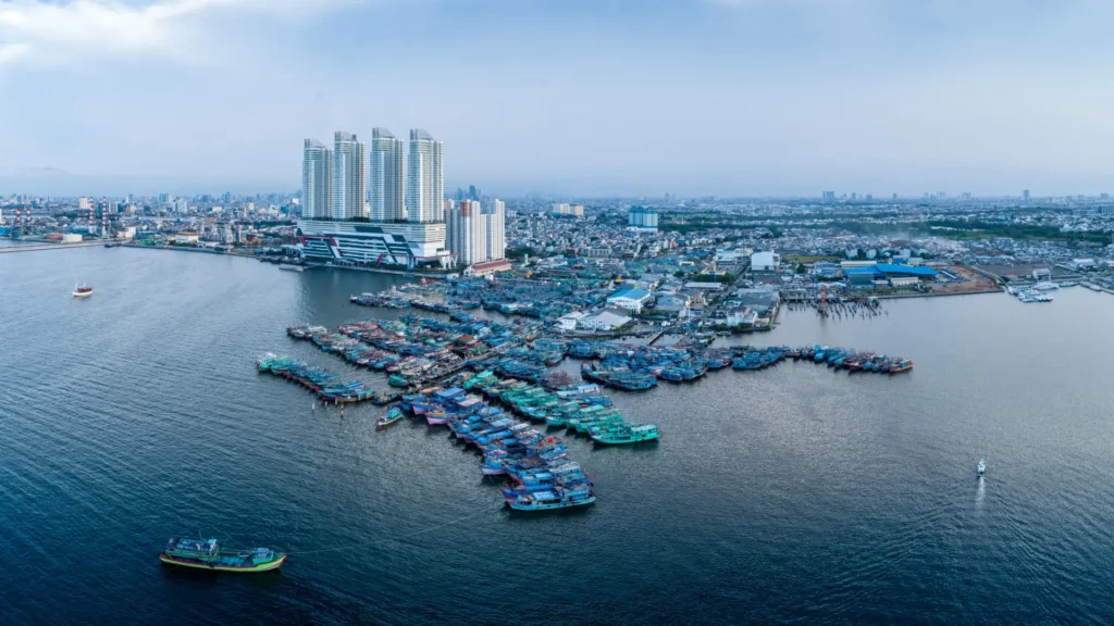
- Jakarta, Indonesia: 13.7 mm/year (with localized areas at 42 mm/year).
- Tianjin, China: 13.5 mm/year.
- Bangkok, Thailand: 8.5 mm/year.
- Lagos, Nigeria: 6.7 mm/year.
- Alexandria, Egypt: 4 mm/year.
The internal variability within these cities is particularly dangerous. In Jakarta, for instance, different neighborhoods sink at radically different rates, making city-wide flood defense strategies incredibly difficult to implement.
Official Responses and Policy Implications
The consensus among the researchers is that while global climate change is a massive, long-term challenge, land subsidence is a localized problem with localized solutions.
"If we want to understand sea-level rise along coastlines and respond effectively, we must not only observe the ocean but also the land itself," says Dr. Julius Oelsmann, lead author of the study. "Especially in densely populated coastal regions, human activities cause the land to subside more strongly—often due to excessive extraction of water and resources."
The Tokyo and Texas Models
Tokyo stands as the definitive success story. In the mid-20th century, parts of the city were sinking by as much as 24 centimeters per year. Through aggressive regulation of groundwater, the development of alternative water supply pipelines, and strict zoning laws, the city successfully arrested the sinking.
Similarly, the Harris-Galveston Subsidence District in Texas provides a blueprint for governance. By forcing industrial and municipal entities to reduce groundwater reliance, they were able to stabilize the ground. These examples prove that subsidence is not an inevitable fate; it is a policy failure that can be rectified.
The Path Forward: Implications for Coastal Policy
The findings necessitate a paradigm shift in coastal planning.
- Integrated Monitoring: Coastal cities must invest in high-resolution geodetic monitoring to understand exactly which neighborhoods are sinking and at what rate.
- Groundwater Governance: Governments must view aquifers as finite, structural assets. Protecting them from over-extraction is now a primary pillar of flood defense.
- Urban Planning: Planners must account for the weight of new developments in soft-soil regions, perhaps incentivizing lower-density building in vulnerable areas.
- Nature-Based Solutions: In some regions, aquifer recharge—injecting treated water back into the ground to maintain pressure—is being explored as a method to "re-inflate" the subsurface and stop the sinking.
The study serves as a wake-up call. While we wait for international climate agreements to slow the melting of the ice sheets, millions of coastal residents are living on sinking ground that requires immediate, local, and decisive action. By addressing the "invisible" half of the sea-level rise equation, we may still have time to save the world’s most vulnerable cities from being reclaimed by the ocean.