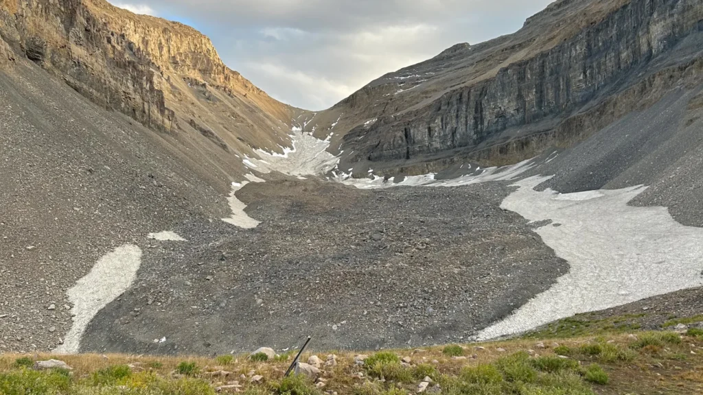
To the casual hiker traversing the rugged high-altitude terrain of Utah’s Wasatch or Uinta ranges, a rock glacier might appear as nothing more than an unsightly, sprawling field of jagged boulders—a tedious obstacle in an otherwise pristine alpine landscape. However, beneath this chaotic veneer of debris lies a geological secret of monumental proportions. Recent research from the University of Utah has peeled back the curtain on these enigmatic formations, revealing them to be massive, ice-rich reservoirs that function as vital, hidden water towers for the state.
The Discovery: Mapping the Invisible
For decades, geologists have understood that rock glaciers—distinct from their “conventional” counterparts—are composed of ice cemented by loose rock and sediment. Unlike the visible, flowing blue ice of traditional glaciers, these formations hide their contents deep within a mantle of talus.
A groundbreaking dual-study project, led by researchers at the University of Utah’s Department of Geology & Geophysics, has now provided the first high-resolution “internal” look at one of the state’s most prominent examples: the Timpanogos Rock Glacier, located beneath the towering summit of Mount Timpanogos. By utilizing sensitive gravimetric technology, the team successfully developed a three-dimensional model of the glacier’s internal structure, effectively creating a "CT scan" for a mountain.
The findings are staggering. The Timpanogos Rock Glacier is composed of approximately 83% ice and only 17% loose rock. Researchers estimate that the formation contains roughly 1.5 million cubic meters of frozen water. To put this into perspective, that volume is sufficient to fill 600 Olympic-sized swimming pools, or, as former graduate student and lead author Bronson Cvijanovich noted, it occupies a volume comparable to the Great Pyramid of Giza.
Chronology of the Investigation
The journey to uncovering the truth beneath Mount Timpanogos was a multi-year endeavor requiring a marriage of rigorous field work and advanced computational physics.
The 2023 Foundation
The preliminary work began in the summer of 2023, when undergraduate researcher Isaiah Davies, then a visiting student from Stanford, spearheaded an investigation into the mechanisms of rock glacier growth. His study, published in Geophysical Research Letters on April 2, 2026, focused on the environmental conditions that allow these formations to persist. Davies and his team identified that these glaciers are not remnants of the last Ice Age—which ended roughly 18,000 years ago—but rather dynamic features that continue to form and evolve through the accumulation of snow buried by ongoing rockfall and erosion from the mountain’s headwalls.
The 2024 Field Campaign
Building upon the conceptual framework established by Davies, Bronson Cvijanovich led a series of intensive field expeditions during the fall of 2024. Operating above Emerald Lake, the team faced the physically grueling task of transporting state-of-the-art gravimeters to the site. Over the course of six trips, the researchers meticulously established a grid across the glacier, taking gravity measurements at 232 distinct locations, each spaced 25 meters apart.
Data Synthesis and Bayesian Inversion
The final phase, completed throughout 2025 and early 2026, involved the painstaking process of “cleaning” the data. To isolate the gravity signatures of the buried ice, the team had to account for minute variables, including the gravitational influence of the sun and moon, terrestrial topography, latitude, and elevation. By applying Bayesian statistical modeling—a method that uses probability to estimate the likelihood of various subterranean compositions—the researchers successfully mapped the ice’s thickness and distribution. The final results were published on August 26, 2026, in the Journal of Geophysical Research.
Supporting Data and the "CT Scan" Methodology
The success of this project hinged on the principle of mass density contrast. Because rock is significantly denser than ice, the gravitational pull at the surface varies depending on what lies directly beneath the instrument.
"When we measure the gravitational acceleration over the rock glacier, we see a larger decrease in that gravitational acceleration as we make measurements over areas with thicker ice," explains Michael Thorne, a professor of geophysics and co-supervisor of the study.
This methodology mimics the diagnostic power of medical imaging. Just as a CT scan allows a physician to differentiate between dense bone and soft tissue, the gravimeter allows a geophysicist to distinguish between the dense, solid rock of the Wasatch mountains and the much lighter, porous ice hidden beneath the surface. This technique provides a non-invasive way to visualize the internal architecture of glaciers, circumventing the limitations of satellite imagery, which can only map the surface footprint of these features.
Official Perspectives: The Experts Speak
The implications of the study are best articulated by those who spent months trudging over the rubble to collect the data.
"There’s a lot of ice that’s hidden in Utah’s mountains," said Leif Anderson, a professor of glaciology and co-supervisor of the research. "When we are high in the mountains and walking across loose rocks or rubble, you don’t realize there could be 120 feet of ice buried beneath your feet."
The researchers emphasize that this is a fundamental shift in our understanding of the Wasatch ecosystem. For years, the scientific community viewed these glaciers as passive, static relics. The new findings suggest they are active participants in the mountain’s hydrology. The erosion of the mountain peaks—the very process that creates the rockfall—is actually the protective mechanism that keeps the ice from melting. By burying the snow under thick layers of debris, the mountains provide the insulation necessary to preserve the ice even through the increasingly hot, dry summers characteristic of the American West.
Global Implications: A Reservoir for the Future
The study of the Timpanogos Rock Glacier is not merely an academic exercise; it serves as a critical case study for global water security. With 836 identified rock glaciers in Utah alone, the researchers extrapolated their findings to understand the potential water volume held across the state.
Their calculations suggest that Utah’s rock glaciers may contain roughly 1 gigaton of water, equivalent to approximately 815,000 acre-feet—an staggering amount for a state plagued by recurring drought.
Global Extrapolation
The team’s mathematical model suggests that the relationship between surface area and internal ice volume found at Timpanogos can be applied to the estimated 50,000 rock glaciers identified worldwide. Collectively, these features could hold up to 48 gigatons of water. Given that one gigaton is equivalent to a cubic kilometer of water—enough to fill 400,000 Olympic swimming pools—the global significance of these hidden reservoirs cannot be overstated.
As climate change continues to alter the timing and availability of snowmelt, these rock glaciers may represent a "slow-release" water source. Unlike standard mountain snowpacks, which melt rapidly in the spring, the thick insulating debris cover on rock glaciers delays the release of meltwater, potentially sustaining streamflow late into the summer months when water demand is at its peak.
Conclusion: A New Era of Glaciology
This research, supported by the U.S. Geological Survey, the National Science Foundation, and the University of Utah’s Wilkes Center for Climate Science & Policy, marks a pivotal moment in mountain hydrology. By revealing the hidden, ice-rich nature of these formations, the team has turned a landscape of "rubble" into a landscape of "resources."
Moving forward, the challenge for geologists will be to monitor these glaciers as temperatures rise. If these reservoirs begin to thaw at an accelerated rate, the impact on alpine ecosystems and downstream water users could be profound. For now, however, the mountains of Utah are keeping their secrets safe beneath a protective layer of stone—a silent, frozen testament to the complexity and resilience of the natural world.