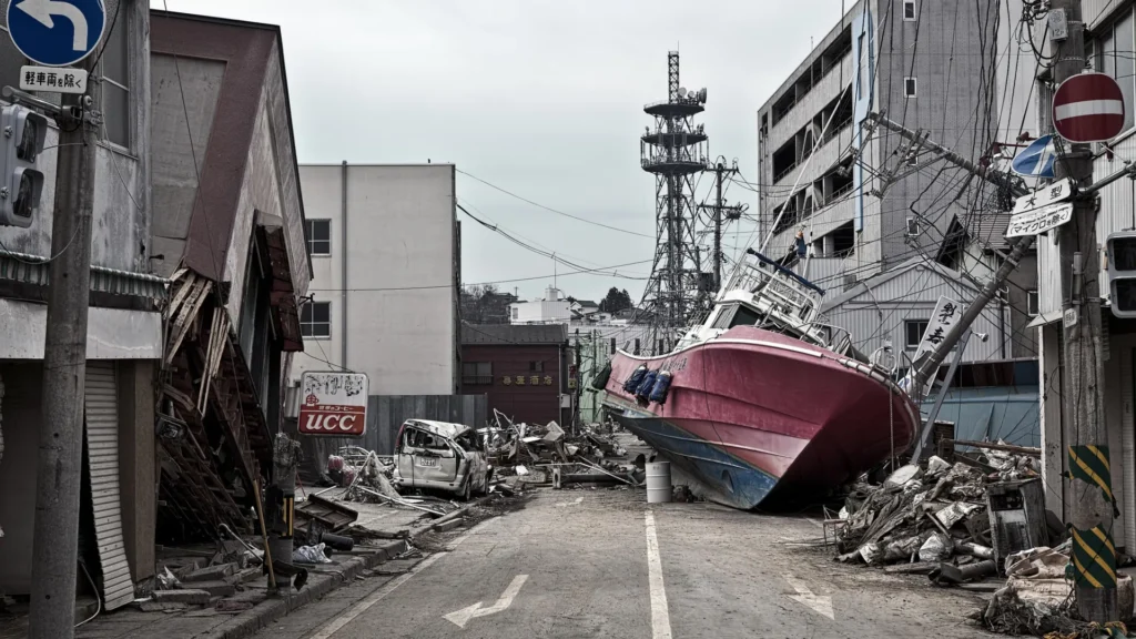
The 2011 Tōhoku earthquake remains etched in the collective memory of the world not merely for its intensity, but for the sheer, unprecedented scale of its destruction. On March 11, 2011, a magnitude 9.1 rupture shattered the seafloor off the coast of Japan, triggering a tsunami that devastated coastal communities and crippled the Fukushima Daiichi nuclear power plant. For over a decade, geophysicists have puzzled over how an earthquake could generate such colossal seafloor displacement.
New research, published in the journal Science and led by an international team of scientists, has finally unveiled the "smoking gun": a thin, slippery layer of pelagic clay buried deep within the Japan Trench. This geological anomaly acted as a lubricant, allowing the fault to rupture all the way to the seafloor, turning what might have been a standard seismic event into a global catastrophe.
The Mechanics of a Global Catastrophe
To understand the severity of the 2011 event, one must first understand how earthquakes typically function. Most large-scale seismic ruptures originate deep within the Earth’s crust—often 30 miles or more below the seafloor. As tectonic plates grind against one another, the friction creates immense stress that is released in a sudden, violent snap.
The Tōhoku earthquake defied this conventional model. Instead of beginning deep within the Earth, the rupture propagated dangerously close to the surface, breaking the fault at a depth of only 15 miles. This shallow rupture allowed the energy of the earthquake to be transmitted directly into the ocean water, displacing a massive volume of the Pacific and creating the wall of water that slammed into Japan’s coastline.
"We’ve never seen anything like that in the time we’ve been observing earthquakes," explains Christine Regalla, an associate professor in Northern Arizona University’s School of Earth and Sustainability and a co-author of the study. "Based on what we understood at the time, we didn’t think that could happen."
The displacement was staggering. Data suggests the seafloor shifted between 130 and 200 feet horizontally. To put that into perspective, Regalla notes: "That’s equivalent to the entire area between Los Angeles and San Francisco moving 130 to 200 feet in just six minutes."
Chronology of Discovery: The Chikyu Expedition
The path to this discovery was neither quick nor easy. Following the 2011 disaster, the global scientific community mobilized to understand the mechanics of the Japan Trench. The centerpiece of this investigation was the research vessel Chikyu, a state-of-the-art drilling ship capable of penetrating deeper into the Earth’s crust than any other vessel in history.
The Deep-Sea Drill
The mission required the team to drill approximately 26,000 feet into the ocean floor—a feat so technically demanding that it earned a spot in the Guinness World Records as the deepest scientific ocean drilling project ever completed.
Analyzing the Core Samples
As the drill core brought up samples of the sub-seafloor, geologists were struck by a distinct, 100-foot-thick layer of pelagic clay. This material is formed over millions of years as microscopic, dust-like particles settle silently through the water column to the deep ocean floor.
When the researchers analyzed the physical properties of this clay in laboratory conditions, they found it was exceptionally soft and weak. It was sandwiched between much harder, more brittle rock formations. In geological terms, this clay acted as a "tear line"—a localized path of least resistance. When the tectonic plates began to move, the stress did not dissipate into the surrounding rock; instead, it funneled into this slippery, unstable layer, facilitating a catastrophic rupture that reached the surface.
Supporting Data: The Physics of Friction
The role of the clay layer cannot be overstated. In the study, co-author Patrick Fulton, an associate professor in Cornell University’s Department of Earth and Atmospheric Sciences, explains the mechanics of the "tear line."
"At the Japan Trench, the geologic layering basically predetermines where the fault will form," says Fulton. "It becomes an extremely focused, extremely weak surface, which makes it easier for ruptures to propagate all the way to the seafloor."
The data suggests that the presence of such soft, clay-rich sediment effectively lowers the friction coefficient of the fault. While most faults are "locked" by friction, the pelagic clay essentially greased the gears of the subduction zone. This allowed the overriding plate to snap forward with minimal resistance, creating the massive vertical displacement of water that is required to trigger a tsunami of that magnitude.
Official Responses and Scientific Implications
The findings have sent ripples through the international geological community. While the study provides long-awaited answers regarding the 2011 event, it also presents a sobering reality for seismic risk assessment globally.
"Japan is one of the world leaders in earthquake and tsunami preparation, but even they weren’t prepared for what happened in 2011," Regalla notes. The study highlights that our current models for earthquake hazards are incomplete if they do not account for the specific sedimentology of the fault zone.
A Global Hazard
The implications extend far beyond the coast of Japan. Similar geological structures—subduction zones with soft, pelagic sediment layers—exist in other parts of the world, including parts of the Pacific Northwest and the Aleutian Islands. The discovery of this "tear line" mechanism suggests that these regions may be more prone to shallow-slip earthquakes than previously calculated.
Furthermore, the research underscores the interconnected nature of the Pacific Rim. "An earthquake and tsunami in Japan doesn’t just impact people who live locally—it also impacts people at the ports and people who live across the ocean," says Regalla. "Think about Hawaii: Their most devastating tsunamis come from Japan and Alaska. These are truly global events."
The Path Forward: Improving Forecasts and Preparedness
The ultimate goal of this research is not merely academic; it is a matter of public safety. By identifying the geological markers of high-risk subduction zones, policymakers and emergency management agencies can better calibrate their disaster preparedness strategies.
Strengthening Infrastructure
With the knowledge that certain faults are "primed" for shallow-rupture megaquakes, engineers can update building codes to withstand higher degrees of lateral displacement. The 2011 event proved that even high-standard infrastructure can fail when the ground moves 200 feet; future construction in high-risk zones may require radically different architectural approaches to remain resilient.
Updating Evacuation and Policy
The study advocates for a shift in how governments communicate risk. If a trench is known to contain these weak clay layers, the "worst-case scenario" models for those regions must be upgraded to include the possibility of a shallow, high-displacement rupture. This affects everything from the placement of critical infrastructure—such as nuclear power plants and chemical storage facilities—to the design of coastal evacuation routes.
"We all need to gain a better understanding of where these events might happen in the future," says Regalla. "Only then can we make emergency plans that will keep everyone safe."
The Next Steps for Research
The international team plans to continue mapping the Japan Trench and other similar subduction zones using seismic reflection surveys and further core sampling. The objective is to create a "global map of vulnerability" that highlights regions where pelagic clay layers or similar geological lubricants might exist.
As the world continues to urbanize along vulnerable coastlines, the lessons learned from the Chikyu expedition are vital. The 2011 earthquake was a tragedy of historical proportions, but it has provided a unique opportunity to peer into the mechanics of the Earth’s crust. By understanding the "tear line" beneath our feet, scientists hope to transform the lessons of the past into a safer future, ensuring that the next time the earth moves, communities are equipped with the knowledge—and the protection—they need to survive.