
For generations, the Grand Canyon has stood as the quintessential icon of geological time—a staggering mile-deep chasm carved by the relentless erosive power of the Colorado River. Yet, beneath its well-documented layers of Paleozoic strata lies a profound geological mystery: the "Great Unconformity," a perplexing gap where over a billion years of Earth’s history seemingly vanished into thin air.
Now, a groundbreaking study led by researchers at the University of Southampton has unveiled a revolutionary theory. Scientists have discovered evidence that the deepest, most ancient basement rocks of the Grand Canyon were not initially brought to the surface by the Colorado River, but rather by an enormous, long-lost cliff system that dominated western North America nearly a billion years before the canyon as we know it existed.
The Great Escarpment: A Prehistoric Continental Divider
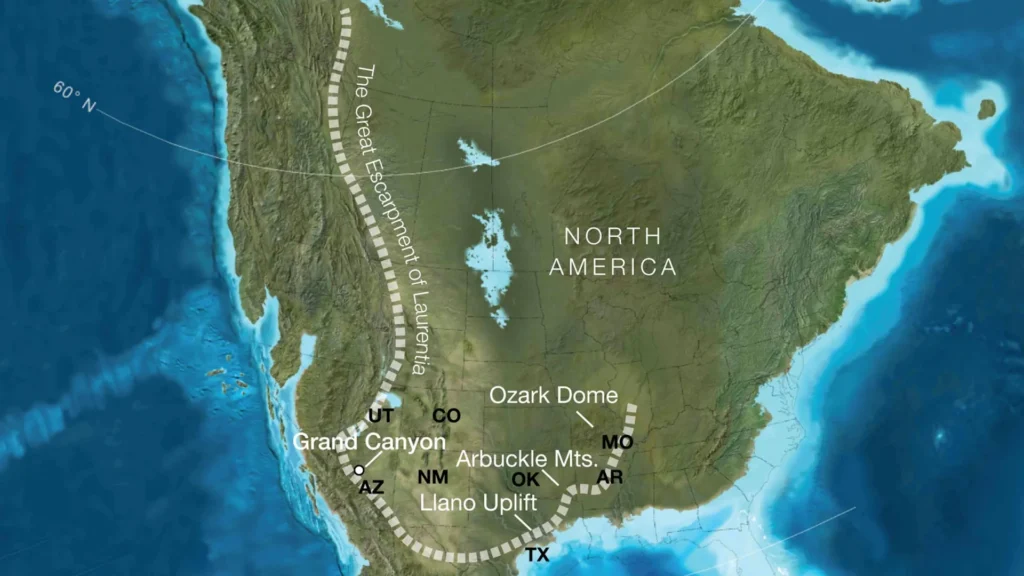
The study, published in the journal Geology, proposes that approximately 800 million years ago, as the supercontinent Rodinia began its slow, tectonic fragmentation, the landscape of North America was dominated by a colossal geological feature known as a "great escarpment."
These were not mere hills, but towering, precipitous cliffs reaching nearly a kilometer in height. They stretched for thousands of kilometers along the western edge of the North American continent, or Laurentia, as it was known at the time. This massive rocky boundary acted as a continental shelf, a barrier that fundamentally altered the drainage patterns and erosional history of the region.
As Rodinia pulled apart, the resulting tectonic stresses created the uplift necessary for this escarpment to flourish. Over tens of millions of years, the relentless forces of weathering and erosion began to gnaw at this immense wall, systematically stripping away vast quantities of overlying material. It was this ancient, colossal erosion that finally exposed the crystalline basement rocks that visitors marvel at today in the depths of the Grand Canyon.
Chronology of a Disappearing World
To understand the scale of this transformation, researchers had to look back into deep time, constructing a timeline that links the breakup of a supercontinent to the present-day topography of the American Southwest.
The Era of Rodinia (800 Million Years Ago)
During this period, North America was part of the supercontinent Rodinia. As internal heat and tectonic shifting began to pull the landmass apart, a "rift-to-drift" cycle initiated. This rifting created a steep, mountainous margin. The researchers suggest that the area now occupied by the Grand Canyon sat in a position relative to the continental edge comparable to the modern Great Escarpment of South Africa or the Serra do Mar in Brazil.
The Great Erosion (800 Million to 500 Million Years Ago)
Following the formation of the escarpment, a long period of tectonic stability allowed for massive, prolonged erosion. As the escarpment migrated inland, it removed an estimated five to ten kilometers of rock in various locations across what are now Arizona, Utah, Idaho, Wyoming, Colorado, Texas, Oklahoma, Arkansas, Missouri, and Illinois. This massive "planing" of the continent is the primary suspect for the formation of the Great Unconformity.
The Modern Era (6 Million Years Ago to Present)
While the ancient escarpment did the "heavy lifting" of exposing the deep basement rocks, the modern Colorado River began its incision only about six million years ago. The river did not create the depth of the canyon from scratch; rather, it exploited the structural weaknesses and the already-exposed ancient rock foundations provided by the tectonic events of nearly a billion years prior.
Supporting Data and Methodological Innovation
The international team—comprising experts from the University of Southampton, the GFZ Helmholtz Centre for Geosciences, the University of Potsdam, and the University of Illinois Urbana-Champaign—utilized a multidisciplinary approach to validate their hypothesis.
By combining sophisticated plate tectonic reconstructions with data models that simulate landscape evolution, the team was able to "reverse-engineer" the topography of the ancient North American interior. They compared their computer-generated models against known geological markers—specifically, the thickness of rock sequences that were missing across the American Southwest.
The results showed a striking correlation: the predicted removal of rock by the migrating escarpment matched the geological evidence of the missing strata in the Great Unconformity. "This long-lived tectonic landscape provides a missing piece in understanding why erosion associated with the Great Unconformity varies so dramatically across the southwestern US," notes Professor Thomas Gernon, lead author of the study.
The data suggests that the escarpment was not a static feature. Much like modern active escarpments, it retreated inland over time. This retreat explains why the depth of the "missing" rock layers varies so significantly across the continent, providing a coherent explanation for a mystery that has puzzled geologists for over a century.
Official Perspectives: Redefining the Canyon’s Origins
Professor Thomas Gernon, a leading authority in Earth Science, emphasizes that this research forces a complete re-evaluation of how we view the Grand Canyon’s history.
"Our paper suggests the Canyon’s basement rocks were progressively brought to the surface as part of an immense escarpment that developed during the breakup of an ancient supercontinent," says Gernon. "The findings also shed light on the formation of the Great Unconformity, a mysterious gap in the rock record that spans over a billion years."
Gernon highlights that the research does not diminish the role of the Colorado River, but rather contextualizes it. "Our work suggests that tectonic uplift related to continental rifting and breakup created both steep slopes and high ground, providing the mountainous terrain that rivers and glaciers could readily erode," he explains.
By comparing the ancient North American landscape to modern active analogs like the Drakensberg in South Africa, the team has successfully bridged the gap between theoretical tectonics and observable physical geology. This comparative methodology is considered a hallmark of the study, allowing scientists to see "North America’s most iconic geologic landmark in an entirely new light."
Implications: A New Lens on Continental Evolution
The implications of this study reach far beyond the borders of Arizona. By identifying the mechanism behind the Great Unconformity in North America, the researchers have provided a template for geologists to study other regions of the world where similar "missing" geological records have hindered our understanding of Earth’s history.
Reshaping the Continent
The presence of a massive, long-lived mountainous rim around the ancient core of North America (Laurentia) would have had profound climatic and ecological consequences. Such a barrier would have dictated the flow of ancient rivers, determined where vital sediments were deposited, and acted as a barrier to the migration of early life forms. It likely played a critical role in the lead-up to the Cambrian Explosion—the rapid diversification of complex life—by influencing when and how rising seas flooded the continental interior.
A Global Model for Geologic History
The research team believes that their findings provide a "window into the forces that shape continents over hundreds of millions of years." In a broader sense, this study serves as a warning against assuming that landscapes are static or that their present-day forms are indicative of their entire histories.
"Our findings could help geologists reinterpret other ancient continental interiors where similarly large gaps occur in records," Gernon adds. "It offers a better understanding of how Earth’s continents have changed, broken apart, and reassembled over hundreds of millions of years."
Conclusion: A Deepened Appreciation for the Grand Canyon
The Grand Canyon is no longer just a site of recent river incision; it is a repository for the tectonic echoes of a world that existed before the rise of complex life. By uncovering the existence of a kilometer-high escarpment that once spanned the heart of the continent, scientists have successfully peeled back a billion-year-old layer of mystery.
As we continue to decipher the history of our planet, the Grand Canyon remains a testament to the fact that the most profound changes in Earth’s landscape are often the result of forces that act over vast, unimaginable stretches of time. The next time a visitor stands on the rim of the Grand Canyon, they are not just looking at a river valley—they are witnessing the final, grand act of a geological drama that began with the death of a supercontinent.