It is a sobering reality of modern science that we possess higher-resolution maps of the cratered surfaces of the Moon and Mars than we do of the vast, crushing depths of our own planet’s oceans. Nowhere is this scientific blind spot more apparent than in the Bismarck Sea, located north of Papua New Guinea. A region defined by profound geological complexity—a chaotic intersection of active subduction zones, transform faults, and spreading centers—the seafloor here remains a cartographic mystery.
That mystery was thrust into the international spotlight on May 8, 2026, when a suite of orbital satellites captured the birth of an unexpected submarine volcanic eruption. While the event has yet to reach the cataclysmic proportions of recent historic eruptions, it has provided the scientific community with an unprecedented opportunity to observe the formation of a potential new island in real-time, leveraging the most advanced remote sensing technology currently in orbit.
Chronology of a Submarine Awakening
The event began not with a visual cue, but with a rhythmic vibration in the Earth’s crust. On May 8, 2026, regional seismometers detected a swarm of earthquakes originating deep beneath the Bismarck Sea. This seismic precursor signaled that magma was migrating upward through the complex tectonic architecture of the Titan Ridge.
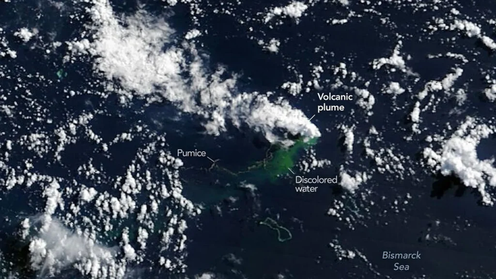
Within hours of the seismic activity, the first visual confirmations arrived from orbit. By May 9, NASA’s Aqua and Terra satellites began transmitting imagery of white, steam-rich volcanic plumes piercing the ocean surface and rising into the troposphere. Simultaneously, the PACE (Plankton, Aerosol, Cloud, Ocean Ecosystem) satellite, using its advanced ocean color sensor, mapped expansive swaths of discolored, sediment-laden water, revealing the massive scale of the plume’s impact on the local marine environment.
As the days progressed, the sophistication of the data collection increased. On May 10 and 11, the European Space Agency’s Sentinel-2 and the NASA/USGS Landsat 9 satellites provided high-resolution snapshots of the surface activity. These images captured the stark contrast of ash plumes reaching several kilometers into the sky. A false-color analysis of the eruption’s infrared signature, captured via the VIIRS instrument on the Suomi NPP satellite on May 12, identified intense thermal anomalies spanning roughly seven square kilometers—a footprint of heat that suggests the eruption is occurring at a significantly shallower depth than previous bathymetric maps of the region had indicated.
The Science of the "Island-naut" Laboratory
The potential for land to emerge from this eruption has galvanized the planetary science community. Jim Garvin, chief scientist at NASA’s Goddard Space Flight Center, describes the event as a rare window into the infancy of geological structures.
"We’re now eagerly waiting to see if a new island is about to be born—something that we’ve only rarely been able to observe with satellites as it happens," Garvin noted.
If the volcanic activity continues to deposit material above the waterline, the resulting landmass would serve as a pristine natural laboratory. Garvin has coined the term "island-nauts" for the researchers who would flock to such a site. Much like the post-eruption studies conducted at Hunga Tonga-Hunga Ha’apai, scientists hope to observe the primary succession of life: the arrival of wind-blown seeds, the colonization of microbes, and the chemical weathering of volcanic rock as it is sculpted by rain and salt spray.
This study is not merely academic. As NASA prepares for the Artemis IV mission to return humans to the Moon, studying how life and geology interact on a newly formed, isolated landmass provides essential analogues for planetary exploration. Understanding the life cycle of a volcanic island—from its explosive birth to its potential erosion and collapse—is a fundamental component of understanding planetary evolution.
Geologic Context: Why Titan Ridge is Unique
To understand the nature of this eruption, one must look at the specific tectonic "plumbing" of the Bismarck Sea. Titan Ridge sits near a volatile intersection where a transform fault meets a back-arc spreading center.
Volcanologist Simon Carn of Michigan Tech explains that this location is the primary reason the eruption has remained relatively mild compared to the 2021 Fukutoku-Okanoba or the 2022 Hunga Tonga-Hunga Ha’apai events. "Spreading centers are generally associated with less explosive activity," Carn stated. "The truly devastating eruptions, the ones that create massive atmospheric shocks and tsunamis, are typically found along subduction zones involving large stratovolcanoes."
The current eruption is characterized by floating pumice rafts—massive, porous volcanic stones that drift with surface currents—and localized steam vents. While the thermal anomalies detected by VIIRS suggest a shallow vent, the lack of massive, long-range ash dispersal suggests that the magma is not currently interacting with a large, trapped volume of seawater in a way that would trigger a phreatomagmatic explosion. However, scientists remain cautious. If the seafloor structure shifts and allows seawater to reach the developing shallow magma chamber, the eruption could escalate significantly.
The Uncertain Duration of Activity
One of the most persistent challenges in volcanology is predicting the "lifespan" of an eruption. The history of the Bismarck Sea offers little in the way of predictability. In 1972, a nearby submarine eruption concluded after only four days. Conversely, an eruption in the St. Andrew Strait, located roughly 100 kilometers away, persisted for nearly four years after beginning in 1957.
Researchers are currently utilizing a multi-agency approach to narrow this window of uncertainty. NASA, the ISRO (Indian Space Research Organisation), and the Canadian Space Agency are integrating data from the NISAR satellite and the RADARSAT Constellation Mission. By synthesizing radar interferometry with optical satellite data, they hope to track the precise rate of seafloor deformation and the growth of any sub-aerial features.
Implications for Global Monitoring
The 2026 Bismarck Sea event serves as a testament to the maturation of remote sensing technology. Twenty years ago, a submarine eruption in such a remote, poorly mapped region might have gone unnoticed by the international scientific community until long after it concluded. Today, the rapid deployment of satellite assets allows for a "cradle-to-grave" analysis of volcanic processes.
This eruption also highlights the critical importance of maintaining global satellite constellations. The synergy between government-operated sensors—like those on the Landsat and Sentinel programs—and commercial satellite imagery has provided a depth of coverage that would have been impossible for any single institution.
As the world watches the Bismarck Sea, the event underscores the broader need for better bathymetric mapping. While the "island-naut" potential is exciting, the event has once again reminded oceanographers that the seafloor is a dynamic, shifting landscape that remains the final frontier of Earth exploration. Whether this specific eruption results in a permanent island or vanishes back into the depths as a submerged tuff cone, the data collected will undoubtedly refine our models of volcanic behavior and planetary formation for years to come.
As Garvin aptly summarized, the ability to watch the Earth "grow" from orbit is a privilege that brings us closer to understanding the processes that shaped our home planet, and by extension, the rocky worlds we are currently preparing to visit among the stars. For now, the world waits to see if the Bismarck Sea will claim a new piece of land, or if the ocean will reclaim the fire that currently burns beneath its waves.