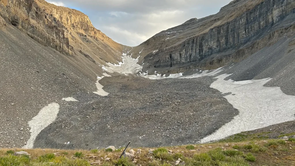
To the casual hiker traversing the rugged high-altitude terrain of Utah’s Wasatch and Uinta ranges, the landscape often appears as nothing more than a chaotic jumble of loose rock and jagged talus. These sprawling fields of debris, scattered across the slopes of the Colorado Plateau and the La Sal Mountains, seem like mere scars of geological erosion. However, beneath this unassuming facade of stone lies a hidden, crystalline treasure: vast quantities of ice, preserved for millennia.
A groundbreaking investigation by geologists at the University of Utah has recently peeled back the curtain on these mysterious formations, known as rock glaciers. By deploying state-of-the-art geophysical techniques at the Timpanogos Rock Glacier—a massive formation sitting beneath the iconic summit of Mount Timpanogos—researchers have finally quantified the frozen water reserves hidden within the state’s mountains. Their findings suggest that these overlooked geological features may be far more critical to the region’s water security than previously imagined.
The Invisible Reservoir: Main Facts and Discovery
Rock glaciers are distinct from their more famous, glistening counterparts. While conventional glaciers consist of exposed ice flowing down mountain valleys, rock glaciers are cloaked in a protective mantle of rock debris. This insulating layer acts as a natural thermos, shielding the underlying ice from the harsh heat of summer.
The recent study focused on the Timpanogos Rock Glacier, one of the largest in the state. By employing a high-precision gravimeter—an instrument capable of detecting minute fluctuations in the Earth’s gravitational pull—the team was able to "see" through the surface rubble. Because ice is significantly less dense than the surrounding rock of the mountain, the instrument registered a subtle decrease in gravitational acceleration over areas where the ice layer was thickest.
The results were staggering. The team discovered that the Timpanogos Rock Glacier is composed of approximately 83% ice and only 17% rock. This translates to roughly 1.5 million cubic meters of frozen water—enough to fill 600 Olympic-sized swimming pools. To provide a sense of scale, Bronson Cvijanovich, a former graduate student and lead author of one of the studies, noted that the volume of this single glacier is roughly equivalent to the Great Pyramid of Giza.
A Chronology of Investigation
The path to these findings was arduous, requiring months of physical fieldwork followed by complex computational modeling.
The Fieldwork Phase (Fall 2024)
In the autumn of 2024, Cvijanovich led a series of six expeditions to the glacier, situated above Emerald Lake. The team established a precise grid of 232 measurement points across the glacier’s surface, with each point spaced exactly 25 meters apart. Carrying sensitive gravimeters over steep, shifting, and treacherous talus slopes, the researchers painstakingly recorded gravitational data point by point.
Data Processing and Statistical Modeling
Collecting the raw data was only the beginning. To isolate the signature of the buried ice, the team had to strip away "noise" caused by external variables. This included correcting for the gravitational influence of the sun and moon, as well as adjustments for local terrain, latitude, and elevation.
Once the data was cleaned, the team utilized Bayesian statistics to construct a three-dimensional image of the glacier’s interior. As Professor of Geophysics Michael Thorne explained, this process was akin to a medical CT scan. The resulting computational model allowed the researchers to visualize the thickness and distribution of the ice, providing the first accurate map of what lies beneath the surface.
Publication and Peer Review
The findings were disseminated in two major scientific journals. The first paper, “Mass Addition to Timpanogos Rock Glacier: Debris-Covered Snow and the Importance of Interannual Variability in Headwall Erosion and Climate,” was published in Geophysical Research Letters on April 2, 2026, with undergraduate researcher Isaiah Davies as the lead author. The second, more detailed look at the internal composition, titled “The internal ice content of Timpanogos Rock Glacier, Utah, USA from 3-D Bayesian inversion of gravity data,” appeared in the Journal of Geophysical Research on August 26, 2026.
Supporting Data: The Global Perspective
The data collected at Mount Timpanogos has served as a benchmark for understanding the other 835 rock glaciers identified across Utah via satellite imagery. By establishing a correlation between surface area and internal ice volume, the researchers were able to scale their estimates to a global level.
The implications are immense. There are approximately 50,000 known rock glaciers worldwide. If the density of ice found at Timpanogos is representative of these formations, they collectively harbor an estimated 48 gigatons of water. Given that a single gigaton is equivalent to one cubic kilometer of water—enough to fill 400,000 Olympic swimming pools—these rock-covered glaciers represent a massive, largely unmonitored terrestrial water reserve.
Within the borders of Utah, the researchers estimate that rock glaciers hold approximately 1 gigaton of water, or roughly 815,000 acre-feet. This volume is particularly significant in a semi-arid state where water scarcity is an increasing concern for both urban centers and agricultural regions.
Official Responses and Expert Insights
The research team, overseen by Michael Thorne and glaciology professor Leif Anderson, emphasizes that these findings challenge common misconceptions about mountain hydrology.
"There’s a lot of ice that’s hidden in Utah’s mountains," said Professor Anderson. "When we are high in the mountains and walking across loose rocks or rubble, you don’t realize there could be 120 feet of ice buried beneath your feet."
Perhaps most importantly, the studies debunk the myth that these glaciers are merely "relics" of the last Ice Age. Contrary to the belief that these ice bodies have been stagnant since the end of the Pleistocene epoch 18,000 years ago, the team’s mathematical model suggests that these glaciers are active, growing, and evolving reservoirs.
"In the Wasatch, the mountains themselves are eroding and burying the snow," Anderson noted. "That’s why the rock glaciers exist." Through a cycle of constant rockfalls, the mountains effectively "recharge" the glaciers by covering fresh snow and preventing it from melting, allowing it to compress into ice over time. This makes these features dynamic participants in the regional water cycle rather than static museum pieces of a bygone era.
Broader Implications: Climate and Water Security
The identification of these massive ice reserves has profound implications for the future of the American West. As global temperatures rise and traditional snowpacks melt earlier in the season, mountain hydrology is becoming increasingly volatile. Rock glaciers, protected by their stone armor, act as high-altitude, long-term water storage systems. They potentially serve as a buffer, slowly releasing water into the mountain watershed long after the winter snow has vanished.
However, the researchers also sound a note of caution. While these glaciers provide a degree of climate resilience, they are not immune to the long-term effects of a warming planet. If the rate of surface debris erosion changes, or if temperatures rise to the point where the insulating layer is compromised, these hidden reservoirs could face accelerated depletion.
Furthermore, the methodologies developed by the team provide a new toolkit for climate scientists. By using gravimetry and Bayesian modeling, researchers can now monitor the health of these hidden glaciers without the need for invasive drilling or expensive, high-risk physical sampling.
The University of Utah project—supported by the National Science Foundation, the U.S. Geological Survey, and the Wilkes Center for Climate Science & Policy—represents a vital intersection of geology, technology, and policy. As the West faces an uncertain climate future, these findings remind us that the most important resources are often hidden in plain sight, tucked away under the shifting rubble of the peaks we walk upon every day. By quantifying the hidden ice, scientists have taken the first step toward better managing one of the state’s most elusive, yet vital, natural assets.