For generations, the Grand Canyon has been viewed through the singular lens of the Colorado River—a majestic, winding chisel that sculpted one of Earth’s most recognizable landscapes over the last six million years. However, a groundbreaking study published in the journal Geology has fundamentally shifted our understanding of this geological icon. Scientists have uncovered evidence of a prehistoric "great escarpment," an enormous cliff system that existed nearly a billion years before the Colorado River began its work. This discovery provides the long-sought explanation for the "Great Unconformity," a perplexing, mile-long gap in the Earth’s rock record that has baffled geologists for over a century.
The Chronology of a Continental Breakup
The story begins approximately 800 million years ago, a time when the Earth looked vastly different. The supercontinent Rodinia—a massive landmass encompassing the majority of the world’s crust—was beginning to fragment. As the tectonic plates pulled apart, the stress placed on the continental interior triggered a massive geological upheaval.
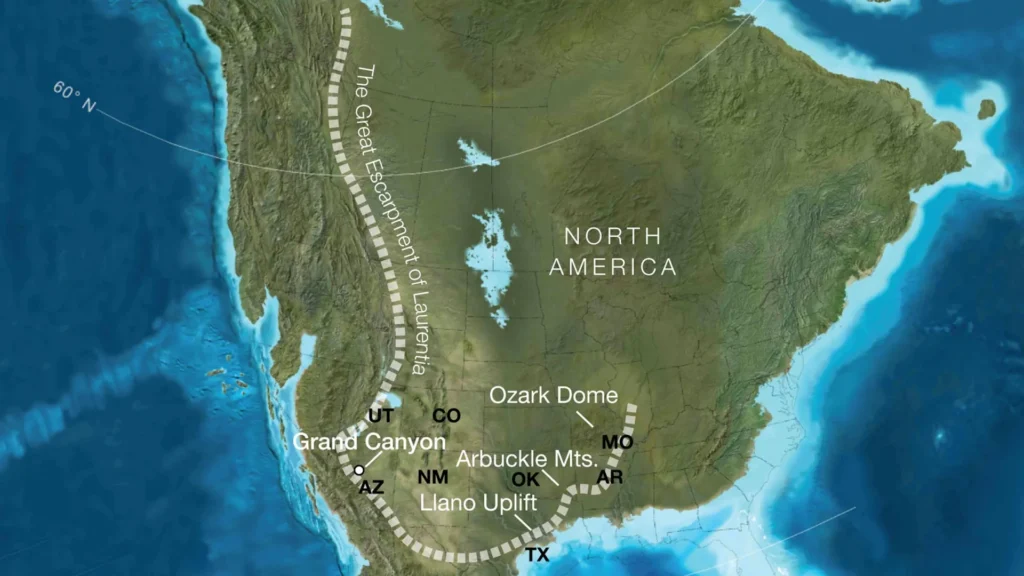
According to the research team, led by the University of Southampton, this rifting event gave rise to a colossal escarpment. These were not mere hills, but towering cliffs reaching heights of up to one kilometer, stretching for thousands of kilometers along the western edge of what would eventually become North America.
For tens of millions of years, this massive rocky boundary served as a primary engine of landscape evolution. As the crust shifted and uplifted, the cliff system gradually migrated inland, subjected to intense erosion. This process did not merely shape the surface; it acted as a massive geological conveyor belt, stripping away between five and eight kilometers of overlying rock in certain regions. It was this prehistoric "sanding down" of the continent that exposed the ancient crystalline basement rocks—the very rocks that today form the dramatic inner gorge of the Grand Canyon.
Supporting Data: Reconstructing the Lost Landscape
To arrive at these conclusions, the international team—comprising researchers from the University of Southampton, the GFZ Helmholtz Centre for Geosciences, the University of Potsdam, and the University of Illinois Urbana-Champaign—employed a sophisticated multi-disciplinary approach.
The researchers synthesized reconstructions of global plate tectonic movements with advanced numerical models of landscape evolution. By mapping the position of the future Grand Canyon relative to the edge of the ancient supercontinent Rodinia, they found a striking correlation. The topographical configuration of the region 800 million years ago mirrored modern-day geological features found in South Africa and Brazil.
"Our results indicate that the Grand Canyon region sat in a position relative to the continental edge that is almost identical to the major escarpments we observe in the Southern Hemisphere today," explains the research team.
The data provided by the team aligns perfectly with long-standing anomalies in the regional geology. Geologists have long known that roughly five to ten kilometers of rock simply "disappeared" from the southwestern United States long before the modern canyon-cutting process began. Until now, the mechanism for this massive removal was unclear. The existence of a migrating, long-lived escarpment provides a cohesive explanation for why this rock volume is missing and why the "Great Unconformity"—the massive missing time gap in the geological column—varies so drastically in depth and character across different regions, including parts of Arizona, Utah, Wyoming, Colorado, and even as far east as Illinois.
Official Perspectives: Decoding the Great Unconformity
Professor Thomas Gernon of the University of Southampton, the study’s lead author, emphasizes that the discovery is more than just a history lesson; it is a vital missing piece of a much larger planetary puzzle.
"The Grand Canyon preserves a geological history stretching back two billion years, yet more than half of that record is missing," Prof. Gernon stated. "Our paper suggests that the Canyon’s basement rocks were progressively brought to the surface as part of an immense escarpment that developed during the breakup of an ancient supercontinent. By identifying this feature, we are effectively solving the mystery of the Great Unconformity."
Gernon notes that the research highlights how tectonic uplift related to continental rifting created both the high ground and the steep slopes necessary for water and glaciers to act as agents of massive erosion. "This long-lived tectonic landscape provides a missing piece in understanding why erosion associated with the Great Unconformity varies so dramatically across the southwestern US," he added.
The researchers argue that this ancient escarpment acted as a "tectonic rim" around Laurentia—the ancient core of North America. This rim would have functioned as a continental barrier, dictating the drainage paths of early river systems and determining where vast quantities of sediment were deposited. These movements would have directly influenced the advance and retreat of ancient seas, setting the stage for the environment that eventually hosted the "Cambrian explosion," the rapid diversification of complex life forms.
Implications for Global Geology
The implications of this study extend far beyond the borders of the United States. By comparing the Grand Canyon’s ancient history with the active, evolving landscapes of modern-day South Africa, India, and Antarctica, the team has provided a new framework for how geologists interpret continental interiors worldwide.
Reinterpreting Ancient Landscapes
The "escarpment model" offers a new lens through which to view other regions where significant gaps in the rock record exist. If vast, migrating cliffs were a common feature of supercontinent fragmentation, then similar geological patterns may be waiting to be identified across the globe. This approach could redefine how scientists reconstruct the topography of Earth’s ancient past.
A New Understanding of Earth’s Evolution
The research underscores the concept of "deep time" in a visceral way. The Grand Canyon, while iconic for its recent erosion by the Colorado River, is revealed to be a multi-act play. The first act—the removal of the basement rock by the ancient escarpment—was the prerequisite for the second act, the spectacular carving we see today.
"Today’s escarpments in Africa, Brazil, India and Antarctica provide windows into the forces that shape continents over hundreds of millions of years," says Prof. Gernon. "By comparing the Grand Canyon’s ancient history with these active landscapes, we are able to see North America’s most iconic geologic landmark in an entirely new light."
Conclusion: A Paradigm Shift in Geomorphology
The findings published in Geology represent a significant paradigm shift in how we understand the evolution of the North American continent. For decades, the focus on the Colorado River as the primary architect of the Grand Canyon has been a necessary, if incomplete, narrative. By looking back an additional billion years to the fragmentation of Rodinia, scientists have connected the dots between the tectonic forces of the deep past and the physical reality of the surface today.
This ancient escarpment was not merely a topographical feature; it was a continental architect, shaping the landscape, governing the flow of rivers, and influencing the biological environment of the prehistoric world. As researchers continue to refine these models, the story of the Grand Canyon will continue to evolve, reminding us that even the most static-seeming features of our planet are the product of immense, long-term processes that have been working in concert for billions of years. The "Great Unconformity" may finally be losing its mystery, replaced by the grand, sweeping narrative of a continent in flux.