Introduction: The Final Frontier Beneath the Waves
Oceanographers frequently remark that we possess more detailed topographical maps of the lunar surface and the rugged plains of Mars than we do of the Earth’s own deep-sea floors. This paradox is nowhere more evident than in the Bismarck Sea, located north of Papua New Guinea. Despite its geological significance—a complex tapestry of tectonic faults, volcanic ridges, deep-sea rifts, and active subduction zones—the region remains a cartographic mystery. Much of this terrain lies at depths that render traditional sonar mapping inefficient or prohibitively expensive.
However, on May 8, 2026, the silence of this underwater frontier was broken. A sudden, unexpected submarine volcanic eruption erupted along Titan Ridge, triggering a global scientific mobilization. By leveraging a suite of modern satellite technologies, researchers are now witnessing the potential birth of a new island—a rare event that promises to transform our understanding of both terrestrial geology and the biological colonization of "blank-slate" ecosystems.
Chronology of the 2026 Bismarck Sea Event
The Opening Tremors (May 8, 2026)
The sequence began in the early hours of May 8, when regional seismometers detected a swarm of earthquakes originating from the Central Bismarck Sea. While submarine seismic activity is not uncommon in this tectonically volatile region, the intensity and rapid succession of the tremors immediately alerted volcanologists. Within hours, the focus shifted from seismic monitoring to orbital observation as satellite sensors began to pick up the first signatures of a major geological disturbance.
The Satellite Response (May 9–12, 2026)
The transition from seismic detection to visual confirmation was swift, thanks to a multi-layered satellite network:
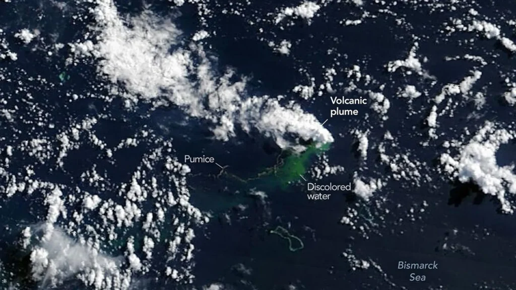
- May 9: NASA’s Aqua and Terra satellites provided the first optical confirmation, capturing images of dense, white, steam-rich volcanic plumes piercing the ocean surface. Simultaneously, the PACE (Plankton, Aerosol, Cloud, Ocean Ecosystem) satellite’s ocean color sensor registered massive swaths of discolored water, indicating significant sediment and chemical discharge.
- May 10–11: High-resolution imagery from the European Space Agency’s (ESA) Sentinel-2 and NASA/USGS Landsat 9 confirmed the presence of ash plumes rising several kilometers into the atmosphere. False-color infrared imagery highlighted the extreme thermal energy radiating from the site.
- May 12: The Suomi NPP satellite’s Visible Infrared Imaging Radiometer Suite (VIIRS) provided the most alarming data point yet: a thermal anomaly covering approximately seven square kilometers. This massive heat signature suggested that a significant volume of magma was reaching, or was already at, the surface.
Supporting Data: Decoding the Heat and Depth
The sheer magnitude of the thermal anomalies detected by VIIRS has surprised many in the scientific community. Simon Carn, a prominent volcanologist at Michigan Tech, notes that the heat signature is inconsistent with the bathymetry currently recorded for the Titan Ridge area.
"There must be a lot of hot material near the surface to generate thermal anomalies of this scale," Carn explained. "Existing charts show water depths of several hundred meters or more in this vicinity. The data suggests the eruption vent is much shallower than previously believed, or that the volcanic edifice is building up rapidly from the seafloor to displace that water column."
The eruption is occurring approximately 16 kilometers southeast of a site that hosted a similar underwater event in 1972. Scientists are currently cross-referencing the new data with 1972 records to determine if this is a reactivation of the same volcanic plumbing system or a new vent entirely. The uncertainty underscores the difficulty of monitoring a region that has been historically under-surveyed.
The Prospect of Island Formation: A Rare Natural Laboratory
One of the most captivating aspects of the 2026 eruption is the emergence of extensive pumice rafts—floating, porous volcanic rocks that drift with ocean currents. These rafts are not merely debris; they are indicators of high-intensity surface-level activity.
Jim Garvin, chief scientist at NASA’s Goddard Space Flight Center, has been vocal about the implications. "We are waiting to see if a new island is about to be born," Garvin said. "It is an event we have only rarely been able to observe in real-time with such high-resolution orbital data."
If the volcanic activity continues to build a tuff cone—a type of crater formed by explosive eruptions in shallow water—the resulting island could become a permanent fixture. However, the lifespan of such landmasses is notoriously precarious. Erosion, wave action, and the structural integrity of the volcanic material often lead to rapid collapse.
The "Island-naut" Initiative
Should a landmass emerge, it will serve as an unprecedented natural laboratory. Garvin and his colleagues are already conceptualizing the study of "island-nauts"—researchers who would monitor the island’s evolution from its inception. This includes:
- Primary Succession: Observing how the first seeds, microbes, and animals colonize a sterile landscape.
- Geomorphology: Measuring how chemical weathering and rainfall reshape the volcanic rock over months and years.
- Erosional Decay: Documenting the battle between volcanic construction and oceanic destruction.
This research mirrors the study of the Hunga Tonga-Hunga Ha’apai island following its 2022 eruption, but with the added benefit of modern, persistent satellite monitoring.
Official Responses and Comparative Volcanology
Despite the intensity of the plumes and the thermal anomalies, experts are cautiously optimistic that this event will remain "mild" compared to recent catastrophes.
Why the Risk Remains Controlled
Volcanologists distinguish between the catastrophic explosive events seen in Hunga Tonga-Hunga Ha’apai (2022) or Fukutoku-Okanoba (2021) and the activity at Titan Ridge. Simon Carn points to the local tectonics as a safeguard.
"Spreading centers, like the one associated with this ridge, are generally characterized by less explosive, ‘effusive’ activity," Carn stated. "The most violent, destructive eruptions typically occur along subduction zones where large stratovolcanoes trap high-pressure gases. While we must remain vigilant, the structural setting here suggests a less explosive pathway."
Uncertain Durations
The duration of the eruption remains the primary unknown. The historical record for the Bismarck Sea is sparse:
- The 1972 Event: Lasted a mere four days.
- The 1957 St. Andrew Strait Event: Persisted for nearly four years.
Given the current thermal data, researchers are preparing for a long-term monitoring mission, utilizing radar data from the NASA-ISRO NISAR satellite and the Canadian Space Agency’s RADARSAT Constellation Mission. These tools allow scientists to track the "growth" of the volcanic edifice regardless of cloud cover or darkness, providing a 24/7 heartbeat of the eruption’s progress.
Implications: Preparing for the Artemis Era
The Bismarck Sea eruption is more than a local geological curiosity; it is a testbed for planetary science. As NASA prepares for the Artemis IV mission and the return of humans to the Moon, the ability to monitor, analyze, and predict the evolution of landforms in remote, hostile environments is critical.
"This eruption presents an exceptional opportunity," Garvin remarked. "By studying how a new piece of Earth is born, shaped by the elements, and colonized by life, we are effectively refining the skills we will need when we explore the lunar surface and beyond. We are learning how to read the geological history of a place while it is still being written."
As of mid-May 2026, the eruption continues. The world watches through the lens of orbiting satellites, waiting to see if the Bismarck Sea will yield a new island—a small, fleeting speck of earth that holds the potential to teach us volumes about the resilience of life and the violent, creative forces that shape our planet.
For the scientific community, the mission is clear: stay focused, observe, and document the creation of a new world before the waves reclaim it, or before it takes its place on the map as the newest addition to the Bismarck archipelago.