
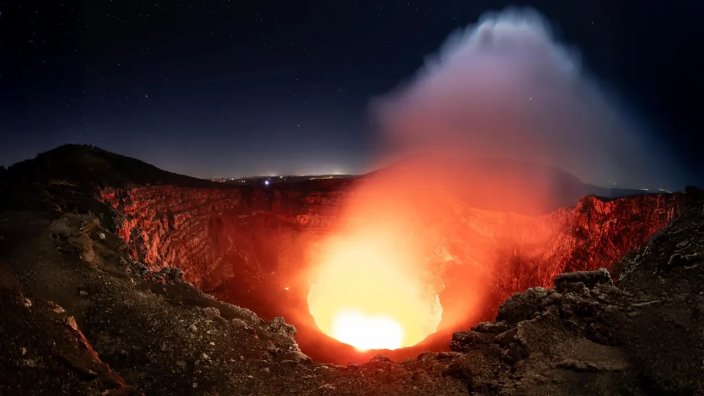
Deep beneath the picturesque landscapes of Nicaragua, where the vibrant Masaya volcano draws thousands of tourists to its glowing, roiling lava lake, a hidden geological drama is unfolding. Recent research conducted by a team at Penn State University has fundamentally altered our understanding of this iconic landmark. By peering through the Earth’s surface using advanced satellite technology, scientists have uncovered evidence of a dual-magma reservoir system, revealing a level of complexity that was previously unknown. This discovery not only reshapes the scientific understanding of Masaya but also provides a vital new roadmap for monitoring a volcano that looms over nearly two million people.
The Dual-Reservoir Revelation: A Complex Plumbing System
For years, Masaya has been viewed as a relatively straightforward volcanic system—a persistent, degassing feature known for its open lava lake. However, the study published in Geophysical Research Letters paints a more intricate portrait. Researchers have identified that the volcano is not fueled by a single, monolithic pool of molten rock, but rather by at least two distinct reservoirs operating in tandem, yet behaving with independent volatility.
The research, which analyzed six years of data from 2018 to 2024, utilized the Sentinel-1 satellite constellation. By employing a sophisticated technique known as Interferometric Synthetic Aperture Radar (InSAR), the team was able to detect minute vertical shifts in the ground surrounding the volcano—movements measured in mere centimeters.
The data revealed a striking dichotomy. While the broader caldera initially subsided—sinking as magma pressure waned—it eventually began to rise, signaling a period of recharge as fresh magma surged into a deep-seated reservoir. Simultaneously, the ground directly surrounding the active Santiago crater continued a persistent trend of subsidence. This diverging behavior indicates that while the deep system is actively inflating, a shallower, secondary reservoir near the crater is experiencing a decrease in magma volume. This "plumbing" complexity is a critical finding, as it suggests that the surface-level lava lake and the deep-seated volcanic architecture may be governed by different, competing physical processes.
A Chronology of Discovery: Tracking Six Years of Volcanic Motion
To understand the scale of this research, one must appreciate the methodology. The project was born from an initiative led by Penn State geoscientist Christelle Wauthier and carried out by a dedicated team, including lead author Lizzie Johnson and graduate researcher Young Cheol Kim.
Phase 1: The Baseline (2018–2020)
During the early years of the study, satellite data indicated a period of general subsidence across the Masaya caldera. In geological terms, this suggests that the magma chambers beneath were cooling or that magma was being withdrawn, causing the surface to depress as the internal pressure dropped.
Phase 2: The Shift (2020–2022)
As the study progressed, a pivotal transition occurred. The broader caldera region began to show signs of uplift. This "inflation" is a classic hallmark of magmatic recharge, where new, molten material migrates from the mantle or deeper crustal zones into the primary reservoir, increasing the pressure and causing the ground to physically bulge outward.
Phase 3: The Divergence (2022–2024)
The most compelling phase of the research occurred when the Santiago crater—the site of the famous lava lake—refused to follow the broader caldera’s trend. While the surrounding landscape rose, the ground near the crater continued to sink. This persistent, localized subsidence confirms the existence of a distinct, shallower reservoir that appears to be draining or depleting even as the deeper system is refilling. This decoupled movement is the smoking gun for a complex, multi-tiered magmatic system.
Technological Precision: How InSAR Sees the Unseen
The ability to map these movements relies on the high-tech capabilities of the Sentinel-1 satellite. Traditional aerial photography is often rendered useless in tropical environments like Nicaragua, where dense cloud cover obscures the ground for long stretches of time.
InSAR bypasses this hurdle by utilizing microwave radar. The system emits signals that can penetrate clouds, rain, and thick vegetation to map the Earth’s surface with millimeter-scale precision. By comparing the returning signals from different orbital passes, scientists can calculate the precise change in distance between the satellite and the ground. If the distance decreases, the ground has moved upward (uplift); if it increases, the ground has moved downward (subsidence).
"Cloud penetration is absolutely essential for monitoring volcanoes in tropical regions," explains Young Cheol Kim. "Because we have these continuous measurements every 12 days, we aren’t just taking snapshots—we are essentially creating a motion picture of the volcano’s internal state. This allows us to differentiate between the ‘noise’ of everyday volcanic activity and the specific, anomalous movements that might signal a shift in hazards."
Implications for Public Safety and Regional Hazard Mitigation
The significance of this research extends far beyond academic curiosity. Masaya is a constant presence in the lives of approximately two million people who reside within a 13-mile radius. As the capital, Managua, continues to expand, the proximity of such an active volcanic system presents a persistent public safety challenge.
"Having a thorough understanding of Masaya’s volcanic activity and its related hazards is critical," says Lizzie Johnson. "While we haven’t seen a major explosive eruption since the 1700s, the volcano is a persistent source of sulfur dioxide. Even without an eruption, these gases can create dangerously poor air quality for surrounding communities."
The discovery of the two-reservoir system provides local authorities and disaster management agencies with a new "baseline" for monitoring. If the pattern of subsidence at the Santiago crater were to suddenly reverse into rapid inflation, it could serve as a vital warning sign of a pressure build-up. By integrating these satellite-derived insights into existing ground-based monitoring systems, scientists can better distinguish between routine degassing and genuine escalations in volcanic activity.
The Human Element: Future Generations of Volcanology
The project also highlights the vital role of academic mentorship in scientific advancement. For lead author Lizzie Johnson, the Masaya project was the cornerstone of her undergraduate honors thesis at Penn State’s Schreyer Honors College. Her transition from a student learning the ropes of InSAR coding to a lead researcher on a published paper serves as a testament to the power of collaborative research.
"I had never had any experience with research prior to this," Johnson reflects. "Learning how to work in a group, analyze complex data sets, and understand the real-world implications of our findings was transformative." Johnson has since moved on to a doctoral program at the University of Hawaii at Manoa, where she continues to push the boundaries of volcano science by using seismic waves to image the depths of Kilauea.
Her journey is part of a broader effort at institutions like Penn State to foster the next generation of geoscientists. With support from the U.S. National Science Foundation, these young researchers are equipped with the computational power and data access needed to solve some of the planet’s most enduring geological mysteries.
Conclusion: A New Era for Masaya
The findings at Masaya volcano serve as a powerful reminder that volcanoes are dynamic, evolving entities. The "static" image of a volcano—even one as iconic as Masaya—often hides a frantic, shifting internal architecture. By identifying the interplay between the deep reservoir and the shallow crater plumbing, the research team has provided a new lens through which to view volcanic risk.
As global monitoring capabilities improve, the combination of satellite remote sensing and advanced computational modeling will likely become the standard for volcano surveillance. While the current findings do not suggest an immediate threat to the people of Nicaragua, they provide a essential foundation for long-term safety. By decoding the language of the ground’s subtle rise and fall, scientists are gaining the ability to "listen" to the volcano, ensuring that if the internal state of Masaya ever shifts toward danger, the world will be listening.