The August Breakup: A New Chapter in Arctic Instability
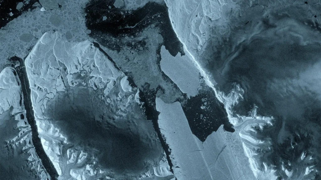
On August 4, 2026, the silence of the high Arctic was broken by a geological event of profound significance. Europe’s Copernicus Sentinel-1 mission, a cornerstone of global Earth observation, captured the precise moment a massive 76-square-kilometer section of the Petermann Glacier’s floating ice tongue sheared away. This calving event—the largest recorded in the Arctic since 2020 and the most significant loss for the Petermann Glacier since 2012—has sent a sprawling, 150-meter-thick "ice island" drifting into the Nares Strait.
The event, which occurred in the rugged northwest reaches of Greenland, serves as a high-definition window into the accelerating volatility of the polar regions. The iceberg, comparable in surface area to the island of Manhattan, is a gargantuan manifestation of the systemic pressures currently reshaping the cryosphere. As this tabular ice mass begins its slow, unpredictable journey, it provides researchers with an unprecedented opportunity to study the mechanics of glacier instability and the far-reaching consequences of a warming climate.
Chronology of a Collapse: From Initial Fissures to Final Break
The collapse of this massive ice shelf was not a sudden accident, but rather the culmination of a months-long process of structural degradation. For years, an international coalition of researchers—comprising experts from the University of Ottawa, the Universities of Stirling, Lancaster, and Leeds, and the Canadian Ice Service—had been monitoring the glacier with growing concern.
The Spring Warning Signs
As early as April 2026, interferometric data collected by the Sentinel-1 satellites began to signal trouble. The radar imagery revealed significant deformation and the emergence of structural fractures deep within the floating ice tongue. These early-warning signs were not merely superficial; they indicated that the glacier’s internal stresses had reached a critical threshold.
The Final Hours
By early August, the pace of deterioration accelerated exponentially. On August 3, 2026, Sentinel-1 radar imagery captured the formation of a distinct, widening fracture pattern along the center of the ice tongue. The structural integrity of the shelf was visibly failing in real-time. Within 24 hours, the structural connection between the main glacier and the eastern tongue vanished entirely, and the massive ice island drifted free, leaving behind a scarred, open lead in the ice shelf.
Supporting Data: The Power of Sentinel-1 and Interferometry
The success of this monitoring effort was made possible by the unique capabilities of the Sentinel-1 mission. In remote, cloud-shrouded regions like Greenland, optical satellites are frequently rendered useless by persistent fog and long periods of polar darkness. Sentinel-1, however, utilizes Synthetic Aperture Radar (SAR), which penetrates cloud cover and functions independently of solar illumination.
The Tandem Phase Advantage
The precision of this observation was enhanced by a rare "tandem phase" involving the Sentinel-1C and the newly launched Sentinel-1D satellites. During the commissioning of the 1D satellite, the mission operated with a one-day repeat interval. This high-frequency data allowed researchers to observe the movement of the glacier’s surface in response to ocean tides with granular detail.
Molly Hammond, a PhD student from the University of Leeds who led the data processing, described the experience as a breakthrough in glaciological study. "The changes we observed were occurring with startling rapidity in the lead-up to the calving event," she noted. "Being able to monitor the crack propagation in near-real time via interferometry has demonstrated the immense value of one-day repeat synthetic aperture data. It turns a static observation into a dynamic, living map of structural failure."
Official Responses and Scientific Perspectives
The scientific community has viewed the event with a mix of academic fascination and profound professional apprehension. The Petermann Glacier, historically one of the most stable features of the Greenland ice sheet, is now signaling that its period of relative dormancy has ended.
Insights from the Field
Adam Garbo, a PhD researcher from the University of Ottawa, has spent years tracking these specific instabilities. "Petermann has long been a sentinel for the health of Greenland’s glaciers," Garbo said. "We’ve anticipated this break for years, watching the rifts deepen and the tongue lose its ability to resist the push of the ice sheet behind it. Seeing it finally happen is remarkable, but it is also a sobering reminder of the speed at which these systems are evolving."
A Rare Arctic Phenomenon
Dr. Anna Crawford of the University of Stirling highlighted the rarity of such events in the northern hemisphere. "While large, tabular icebergs are common features in the Southern Ocean around the Antarctic ice shelves, they are far rarer in the Arctic," she explained. "This creates a unique laboratory. By studying how these Arctic ice islands behave, we can calibrate our models to better understand how the deterioration of ice shelves contributes to sea-level rise and the shifting dynamics of the surrounding ocean."
Martin Wearing, representing the European Space Agency (ESA), underscored the importance of the ARCTEX project in funding this investigation. "This is a unique opportunity to study how a vast ice mass drifts, evolves, and eventually fragments," Wearing noted. "Satellite missions provide the long-term, systematic observations necessary to track these changes, and we are pleased that our Earth observation missions are enabling such critical scientific inquiry."
Implications: A Future of Continued Uncertainty
The loss of this 76-square-kilometer block is likely only the beginning. Current data suggests that two additional ice islands, measuring approximately 97 and 87 square kilometers, are already separated by existing rifts and are poised to detach as the current season progresses.
Ecological and Maritime Risks
The departure of this ice island has immediate, practical implications for the Arctic region. The Canadian Ice Service, working in tandem with international partners, has begun the complex task of tracking the iceberg’s trajectory. Large ice masses of this magnitude represent a tangible hazard to shipping lanes and offshore infrastructure.
As the ice island drifts, it will begin the long, slow process of calving into smaller fragments. While a 76-square-kilometer island is easy to track, its eventual disintegration into "growlers" and smaller icebergs creates a maritime environment that is notoriously difficult to navigate. The threat is not static; it is a moving, evolving risk that will persist in the North Atlantic for years as the ice slowly melts and retreats.
The Broader Climate Context
Beyond the immediate maritime hazards, the event underscores a shift in the "Earth system." The Petermann Glacier serves as a regulator for the ice mass flowing from the interior of Greenland. When a floating ice tongue breaks, the "back pressure" on the land-based glacier is reduced, which can lead to an increase in the velocity of the glacier’s flow toward the sea.
This, in turn, accelerates the transfer of ice from the land into the ocean—a primary driver of global sea-level rise. While the detachment of one ice island may seem like an isolated event, it is part of a broader, accelerating trend of polar mass loss. Scientists are now focused on how this event will alter the flow dynamics of the Petermann catchment area in the coming decades.
Conclusion: Watching the Horizon
As the sun begins to set earlier over the Nares Strait, the massive ice island remains a floating testament to the changing climate. Researchers will continue their vigil, using a combination of satellite imagery, aerial surveys, and oceanic tracking to document every stage of the iceberg’s lifecycle.
The 2026 Petermann calving event will be studied for years to come, not just for the magnitude of the ice loss, but for the clarity of the warning it provides. It represents the intersection of advanced space-based technology and the raw, untamable forces of the Arctic environment. As the international scientific community continues to analyze the data, one thing is certain: the Arctic is no longer the static, unchanging landscape it was once perceived to be. It is a region in motion, and the world is now watching closely to see what happens next.