To the casual hiker traversing the rugged, high-altitude terrain of Utah’s Wasatch and Uinta ranges, the landscape often appears as nothing more than a chaotic jumble of talus—loose, broken rock tumbling down from jagged peaks. Yet, beneath these unassuming, sprawling fields of debris lies a secret that is only now being fully quantified by science: massive, ancient reservoirs of ice.
New research from the University of Utah has peered beneath the rubble of the Timpanogos Rock Glacier, revealing a hidden world of frozen water that challenges our understanding of mountain hydrology. By employing advanced gravimetric technology and innovative Bayesian statistical modeling, geologists have successfully created a 3D "CT scan" of one of the state’s most prominent rock glaciers. The findings suggest that these formations, long dismissed as mere geological curiosities, are actually vital, massive stores of water that have persisted for millennia.
The Hidden Anatomy of a Mountain Glacier
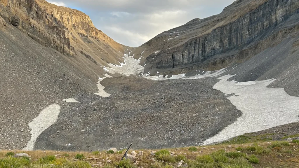
Rock glaciers differ significantly from the iconic, shimmering blue ice sheets of the Arctic or the Alps. While traditional glaciers are exposed to the elements, rock glaciers are insulated by a thick "blanket" of rock and debris. This protective layer acts as a thermal shield, preventing the underlying ice from succumbing to the heat of the summer sun.
At the Timpanogos Rock Glacier, located directly beneath the summit of Mount Timpanogos near Salt Lake City, the scale of this hidden resource is staggering. The recent study, published in the Journal of Geophysical Research, estimates that this single formation contains approximately 1.5 million cubic meters of frozen water. To put that into perspective, it is enough to fill 600 Olympic-sized swimming pools.
"Timpanogos Rock Glacier is surprisingly ice-rich," says Bronson Cvijanovich, a former graduate student in the University of Utah’s Department of Geology & Geophysics and lead author of the study. "Our data shows it is 83% ice and only 17% loose rock. It’s essentially a block of ice with a stone veneer."
The sheer volume is difficult to fathom; if the ice were extracted and stacked, it would rival the size of the Great Pyramid of Giza.
A Chronology of Discovery: From Fieldwork to Data Modeling
The path to these findings was paved by months of grueling physical labor and sophisticated computational analysis. The project, overseen by geophysics professor Michael Thorne and glaciology professor Leif Anderson, began in earnest during the fall of 2024.
The Field Campaign (Fall 2024)
Cvijanovich led a dedicated team on six separate expeditions to the site, which sits above Emerald Lake. The mission was to capture precise gravity measurements across the glacier. The team established a rigorous grid, taking readings at 232 distinct locations, each separated by approximately 25 meters (80 feet).
The tool of choice was a state-of-the-art gravimeter. Because ice is significantly less dense than the surrounding mountain bedrock, it exerts a slightly weaker gravitational pull. By detecting these microscopic variations in gravity, the researchers could effectively "see" the depth and thickness of the ice hidden beneath the surface.
The Computational Breakthrough (2025–2026)
Raw data collection was only the beginning. To create an accurate 3D map, the team had to scrub the data of environmental "noise"—adjusting for the gravitational influence of the sun and moon, as well as variations caused by the site’s elevation, latitude, and local topography.
"We spent months of computation time doing the imaging with our new techniques," Professor Thorne explains. By applying Bayesian statistics—a mathematical framework for updating the probability of a hypothesis as more evidence becomes available—the team successfully reconstructed the internal structure of the glacier, providing a clarity that satellite imagery alone could never achieve.
Understanding the "Ice-Rock" Synergy
For years, many believed that rock glaciers were merely remnants of the last Ice Age, left to stagnate as the climate warmed. However, the second study in this series, published in Geophysical Research Letters on April 2, 2026, overturns that narrative.
Led by Stanford undergraduate Isaiah Davies, the research team found that these formations are not relics of a 20,000-year-old past. Instead, they are dynamic, evolving systems. The team developed a mathematical model demonstrating that rock glaciers grow through a continuous process of erosion and burial. As the steep walls of the Wasatch Mountains erode, they drop debris onto persistent patches of snow. Over years and centuries, this debris acts as a protective layer, allowing the snow to compress into ice rather than melting away.
This discovery fundamentally shifts our view of rock glaciers from "dead" geological features to active, accumulating reservoirs that have developed in the post-Ice Age era.
Implications for Global Water Security
The findings at Mount Timpanogos serve as a "Rosetta Stone" for the rest of the region and, indeed, the world. There are 836 identified rock glaciers in Utah alone. By establishing a firm relationship between a glacier’s surface area and its internal ice volume, the researchers were able to scale their findings to a global level.
The Global Perspective
There are an estimated 50,000 rock glaciers across the globe. Using the Timpanogos model, the researchers estimate that these formations collectively hold approximately 48 gigatons of water. Given that one gigaton is equivalent to one cubic kilometer of water—enough to fill 400,000 Olympic swimming pools—the total volume is vast.
Within Utah, the team estimates that rock glaciers hold roughly 1 gigaton of water, or 815,000 acre-feet. This represents a significant, yet largely unmonitored, mountain water reserve.
A Hidden Climate Buffer
As the climate continues to fluctuate, understanding these reservoirs becomes a matter of water security. In arid states like Utah, where snowpack serves as the primary water tower for agriculture, industry, and urban life, the "hidden" ice in rock glaciers acts as a potential buffer.
"When we are high in the mountains and walking across loose rocks or rubble, you don’t realize there could be 120 feet of ice buried beneath your feet," says Professor Leif Anderson. This buried ice is more resilient to atmospheric warming than traditional snowpack, as it is insulated by meters of stone.
Looking Ahead: Why It Matters
The research represents a collaborative effort supported by the U.S. Geological Survey, the National Science Foundation, and the University of Utah’s Wilkes Center for Climate Science & Policy. It highlights the importance of undergraduate participation in high-stakes research, as seen in the work of Isaiah Davies and the support of the university’s Office of Undergraduate Research.
As the scientific community moves forward, the next step is to monitor how these glaciers respond to long-term climate trends. Will this ice remain stable, or is it reaching a tipping point where it, too, will begin to melt?
"We are just beginning to understand the role these features play in the mountain ecosystem," Thorne concludes. "We’ve spent decades looking at the surface, but the real story—and the real water—is what’s happening underneath."
By mapping the hidden depths of the Wasatch, these geologists have provided more than just a 3D image; they have provided a vital piece of the puzzle in managing water resources for an increasingly thirsty future. Whether these reservoirs will prove to be a permanent fixture of the high mountains or a fleeting resource remains a question for future study, but one thing is certain: the rocky slopes of Utah hold far more life-sustaining water than the naked eye would ever lead us to believe.